Creag Liath and Breabag
| Creag Liath |
815m (2674 ft)
OS Sheet 15; NC 287158 |
| Breabag |
715m
OS Sheet 15; NC 293180 |
| Our Ascent: |
31 July 2001 |
Introduction
Seen from the road these two mountains form the bulk of the long ridge
of very rough terrain south on Inchnadamph and Conival. Neither peak has a high
or pronounced summit and are more akin to long ridges than specific tops. Being
somewhat lower than their northern Munro neighbours they are much less
frequented and an exploration is unlikely to meet many other walkers - if any -
even in the height of the summer season. The ridge forms the western arm of the
ridges that enclose Glen Oykel of Benmore Forest to the East. This area is
extremely remote and rough. The name Breabag applies to the section of
ridge to the north whilst the higher and more rounded southern top is un-named
on OS maps - the name Creag Liath is take from the named crag on the
western side of the hillside.
This walk gives the best views of the
extensive ridges to Ben More hidden
on the East side of the mountain.
Our Ascent
 The
hills were under cloud in the morning but it was clear and sunny at the coast
so we were hopeful of a day when the tops would clear. We drove round to the
car park at the fish farm at the entrance to the Allt nan Uamh. This is
the path to the bone caves some 2km up
the valley (not 4km as shown on the signpost) and is always popular with
visitors.
The
hills were under cloud in the morning but it was clear and sunny at the coast
so we were hopeful of a day when the tops would clear. We drove round to the
car park at the fish farm at the entrance to the Allt nan Uamh. This is
the path to the bone caves some 2km up
the valley (not 4km as shown on the signpost) and is always popular with
visitors.
The sun was shining as we set off along the prepared path, passing the
large spring where the majority of the water that fills the river emerges from.
There much be something in the water as a green slimey weed covers the rocks
downstream from the spring. A smaller second spring lies a few metres further
on but after that the river valley is dry. We ignored the path that crosses the
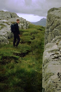
river bed to climb the hillside to the caves and continued past on the soft
grass in the valley bottom. A rough and intermittant path follows the valley
just to the north of the river. One kilometre beyond the caves the valley
narrows and the walls rise in height. At the far end of this ravine is an
impressive waterfall - the stream disappearing underground just below the
plunge pool. The path takes to the narrow sheep and deer tracks across the
steep loose hillside - care is needed.
 We continued up the valley over
rough ground of peat and heather. There was some debate as to which streams
were shown on the map but not on the gorund - and those on the ground but not
on the map. A few hundred yards further on the stream tumbles over an
impressive cascade, the path again climbing to the left on narrow tracks.
Beyond this the terrain opens up to give a wider view of the surrounding hills.
Amongst the heather grows bilberries and there were ample ripe and sweet
berries to be had. High up on the hillside was a large herd of grazing deer -
we counted over fifty head.
We continued up the valley over
rough ground of peat and heather. There was some debate as to which streams
were shown on the map but not on the gorund - and those on the ground but not
on the map. A few hundred yards further on the stream tumbles over an
impressive cascade, the path again climbing to the left on narrow tracks.
Beyond this the terrain opens up to give a wider view of the surrounding hills.
Amongst the heather grows bilberries and there were ample ripe and sweet
berries to be had. High up on the hillside was a large herd of grazing deer -
we counted over fifty head.
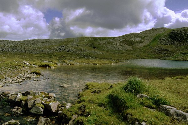
Ahead the terrain changes to one of rocky crags, broken pavements and
piles of shattered rock. Our target was a small lochan shown on the map just
below the ridge between Breabag and the higher top to the south. This was still
some one and a half kilometres distant - a stream could be seen falling over a
long crag high on the skyline and the lochan obviously lay above that.
We climbed the increasingly broken ground, picking up a path that cut
diagonally up the final crag to deliver us to the lip of the small lochan high
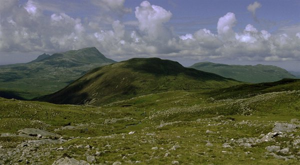
up on the hillside. Behind us (west) lay the Coigach hills - sillhouetted grey
in the sun with clouds drifting on and off the tops. We gained the ridge and
rested with a chocolate bar.
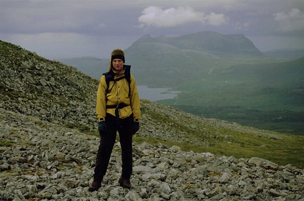
The higher summit lay approximately one and a half kilometres to the
south, 150m higher over (from this angle) a rounded hill. We picked our way
through the broken stones up the easy slopes. As height was gained the Conival
to Ben More ridge stretched impressively behind us in the northern aspect. The
corrie lochan below Ben More was drained by waterfalls running white with water
towards us.
 We
crossed several bands of rocks before reaching a first top and cairn. We passed
a group of walkers who had looped a direct assault on the summit and were
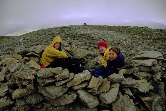
returning by our approach route. The summit carries several tops separated by
grass. The highest top is the furthest one (most southerly) and offers a
shelter of stones surrounding the base of an old trig point - the brass point
still visible in the base rock.
We
crossed several bands of rocks before reaching a first top and cairn. We passed
a group of walkers who had looped a direct assault on the summit and were
returning by our approach route. The summit carries several tops separated by
grass. The highest top is the furthest one (most southerly) and offers a
shelter of stones surrounding the base of an old trig point - the brass point
still visible in the base rock.
Here we lunched (2:15pm) whilst cloud reeled in and out covering the
top. It was somewhat chilly in the strong wind. The cloud cleared as we picked
our way back down to the lochan in the col - from above we had a clear view of
the hillside and could make our way on the grass virtually all the way down.
Here we removed our additional layers of clothing and set off up the lower
slope to the nearer summit of Breabag. This section is much more rocky with
broken pavements covering large areas. We crossed several ridges, including one
six foot dyke that cuts across the entire ridge. We soon reached the wind swept
summit - now very close under Conival although this was now dark and frequently
covered by cloud.

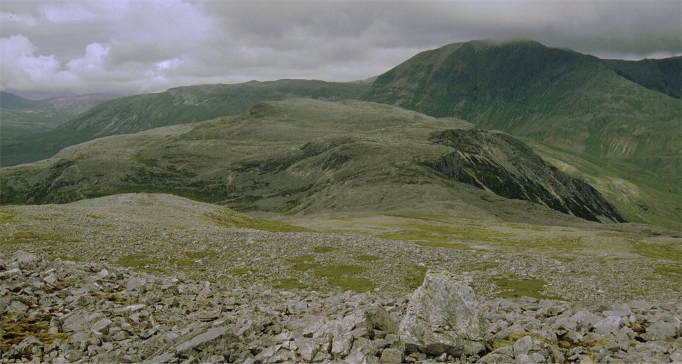
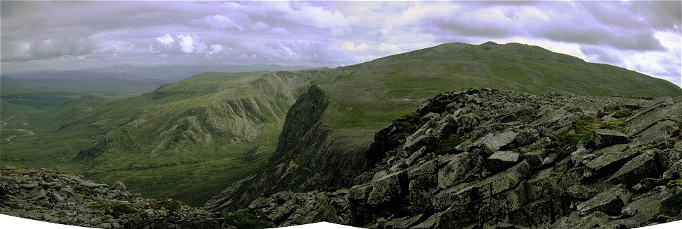
Looking back the true character of Creag Liath is seen with massive
corries and broken cliffs on the eastern side which had been hidden from view.
The wide and desolate Glen Oykel opens out below the heavily shattered cliffs
on the eastern rim of the top. We explored the cliffs as we made our way back
along the ridge. The lochan we had passed on our ascent was below us, perched
on the edge of the col. We crossed the top of a large gully falling away left
to the depths of Glen Oykel before taking a grassy gully running in the
opposite direction back to the headwaters og the Allt na Uamh. After a
final scramble over rough rocks we gained the floor of the high valley and
followed this down. The area around the summit ridge is all broken rock - the
grassy gully we had followed down was virtually invisible from below.
Lower down were were able to pick up rough if intermittant paths all the
way down making for a rapid descent. The herd of deer were still grizing the
high slopes. We paused for a quick drink at a waterfall and soon found
ourselves under the caves again. From here it was only a 25 minute stroll down
the valley now bathed in sunshine and we reached the car at 5:45pm.
This walk makes an excellant outing. As expected we had seen few people
- the party noted above and a group of three that followed us off the first
top. It is well worth taking in both tops having gained the height, with the
extensive view of the Conival and Ben More ridges most impressive. An
exploration of the eastern side would make a most dramatic and remote two or
three day walk.


