| Name of Waterfall: | Eas a Chual Aluinn |
| Height: | 200m (650 ft) |
| Map Reference: | OS Sheet 15; NC 280277 |
| Our Ascents: | 12 August 1993 |
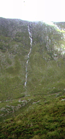
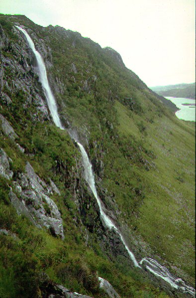
This is the highest waterfall in Britain. The stream launches itself over the cliff edge and plunges nearly 200m in two cascades to the valley floor below. The stream then flows into Loch Beag, an extension to Loch Glencoul that runs inland from Kylesku. The falls are often compared to the Falls of Glomach in Kintail which, not being quite so high, do usually carry more water and plunge deep into a ravine. The character of these falls is therefore very different and the normal approach over the hills from the west takes you through very barren and rocky surroundings. As if this wasn't enough of an attraction, on the opposite side of the valley the Eas-an-t-Strutha Ghil is even higher giving a spectacular 290m cascade down the valley side.
The falls are best visited after recent rain to ensure there is a good
spectacle to reward the effort of the walk. Take note that the path climbs to
over 450m through a pass and the route can be very difficult to relocate in
mist should you miss your way on the return. You can cross the stream right at
the very lip of the fall (with care) and pick your way down to a shoulder on
the east side to get a better view of the fall. Guide books note that the steep
grass cliff can be descended to the valley floor - if wet the grass will be
very slippery - but there is no real reason to do this as there is no easy
route out along the valley.
The usual approach route is from the A894 road just north of the highest point between Loch Assynt and Kylesku, at the south end of Loch na Gainmhich; this is the route we followed below. An alternative walk from Unapool along the south shore of Loch Glencoul is rough and largely trackless - and involves the narrow traverse of a cliff some 50m above the loch. The falls are not visible from Kylesku but boat trips are run during the summer season to view the falls from Loch Beag; but you cannot get nearer than 1.5 km so take your binoculars.
Parking the car by the roadside the path cuts across to the south of Loch na Gainmhich before turning west and climbing steeply over Bealach a' Bhuirich. To start with the expansive mountain of Quinag in the east dominates, but as the pass closes in the barren rock architecture of Glas Bheinn takes over and you are very concious of the wilderness you are entering. The bealach translates as pass of the roaring and very apt this is; in 1991 we set out on this walk but as we cowered in mist with rain and a howling gale whistling through the pass we thought better of it and turned back.
The path climbs above an upper loch, Loch Bealach a' Bhuirich, before dropping sharply down the other side. After a further kilometre the stream is reached which is then followed, over wet and boggy ground, down to lip of the fall. By now all the height gained over the pass, some 200 m, has been lost.
We crossed the lip of the fall to reach a shoulder on the far side, giving a better view of the double cascade. As we tackled the haul back uphill over the peat hags some heavy squalls passed over. It seems a long 5 km to retrace our steps through the pass and back to the car. We drove down to Kylesku for a drink and meal before continuing north to our campsite at Scourie.
![]()
![]()
![]()