| Name of Top: | Sail Gharbh |
| Height: | 808m (2652 ft) |
| Map Reference: | OS Sheet 15; NC 209292 |
| Our Ascents: | August 1991 August 1999 |
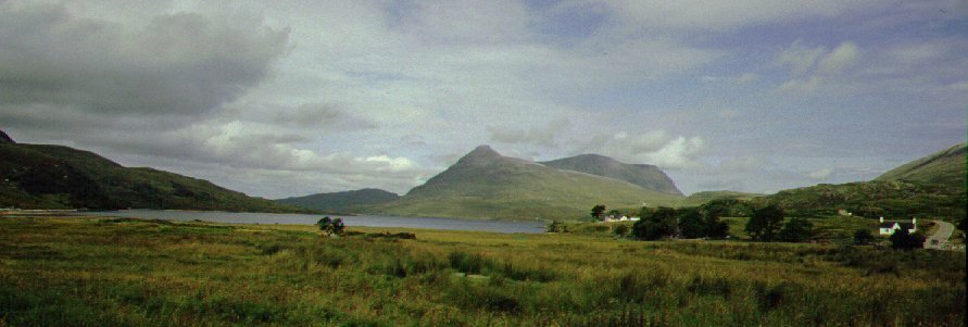
Quinag is the most northerly mountain in Assynt and possesses three main ridges laid out in a giant Y. The southern ridge over Spidean Coinich dominates the horizon as you drive north along the shores of Loch Assynt. The road forks at Skiag Bridge with the A894 continuing the route north over the (relatively) new bridge at Kylesku. As the road climbs to the pass between Quinag and Glas Bheinn it makes a convenient starting point for an ascent of the mountain. The highest summit is Sail Garbh forming the north east ridge of the Y outline, this ridge continuing to the Barrel Buttress - an impressive feature that towers over the houses around Kylesku.
The most convenient starting point is at the highest section of the A894 road 3km north of Skiag Bridge; this gives an advantage of nearly 250m in height. An obvious route follows the edge of the south ridge (it starts by heading west before turning northerly); the odd outcrop seen in silhouette at the top of the ridge is a knoll about 700m short of the first main top. The ridge continues over a second top before narrowing and dropping sharply to a low col at Bealach a Chornaidh.
An alternative is to follow the stalkers path as it swings on a route slightly to the north into the corrie and Loch Bealach Cornaidh; the path continue up into the corrie. From here pass to the north of the loch and ascend the slope to the bealach. The guide books also indicate that this point can be reached from the Lochinver road at Tumor - although this would make a circular walk more difficult.
From the
ridge to main top of Sail Gharbh can be reached easily - contouring
around the intermediate top on grassy slopes. Once at the trig point it is
worth continuing a few hundred metres to the north to look down on the lochs,
road and bridge at Kylesku. The final northern ridge (one we have not explored)
also runs from the intermediate top, passing over an unusual 'truncated' top
which can also be bypassed, to end at Sail Gorm.
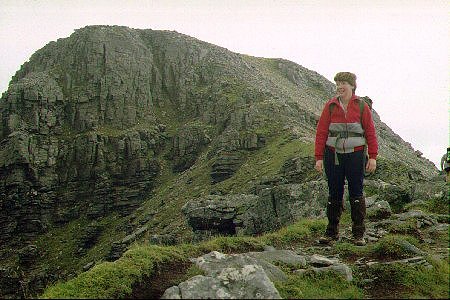
It was cloudy as we left the car by the roadside and crossed the stream - we were unsure how far we would get as the steep slopes would not be a sensible proposition for us in mist. Walking was much easier once we had cleared the deep heather and got onto the rocky outcrops of the ridge. We got to the first top to find the rest of the ridge still in cloud so Andrew and Angela stopped here whilst Susan and Simon carried on to reach the main top of Spidean Coinich, some 150m higher. It almost immediately cleared so they followed on and by the time the top was reached the all ridges of the mountain were visible.
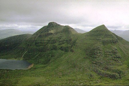
 We continued along the ridge
over the next top - some of the descents involving light scrambling. The ridge
narrows and being around 1000ft above Lochan Bealach Cornaidh in the
corrie below gives a grand sense of height. It is a very steep descent to the
low bealach although there is a clear path to pick your way down. By now Andrew
was getting tired so it was decided that he should rest before dropping down
the grass slope to the corrie floor and start the walk home. Meanwhile Susan
and Simon struck across the grass in a rising traverse to get onto the north
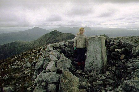
east ridge, with an easy climb to the main summit of Sail Garbh. After
taking a photo by the summit trig point we strolled further north so that we
could look down on the sea lochs and road bridge at Kylesku. We retraced our
steps and dropped to the valley floor to catch up with the other two, picking
up a clear path that leads across the hillside and back to our starting point.
It was late enough in the afternoon (or early enough in the evening) to call in
for supper at the Inn in Kylesku before returning south to our campsite at
Achnahaird.
We continued along the ridge
over the next top - some of the descents involving light scrambling. The ridge
narrows and being around 1000ft above Lochan Bealach Cornaidh in the
corrie below gives a grand sense of height. It is a very steep descent to the
low bealach although there is a clear path to pick your way down. By now Andrew
was getting tired so it was decided that he should rest before dropping down
the grass slope to the corrie floor and start the walk home. Meanwhile Susan
and Simon struck across the grass in a rising traverse to get onto the north
east ridge, with an easy climb to the main summit of Sail Garbh. After
taking a photo by the summit trig point we strolled further north so that we
could look down on the sea lochs and road bridge at Kylesku. We retraced our
steps and dropped to the valley floor to catch up with the other two, picking
up a clear path that leads across the hillside and back to our starting point.
It was late enough in the afternoon (or early enough in the evening) to call in
for supper at the Inn in Kylesku before returning south to our campsite at
Achnahaird.
It was time for another assault on this mountain, this time aiming to take in all the tops. By the time we had travelled from the campsite at Achiltilbuie it was 11:00am by the time we left the old quarry that is used as a parking place. There was a fair bit of cloud with a slight (but cold) NE wind blowing - it promised a good day once the initial onslaught of the viscous midges had settled down.
With the road providing a good start in terms of height, we set off along the clear path (the burn now bridged) to follow the flat rocky slabs that form the escarpment rising to Spidean Coinich. With the sun coming through we paused to don suncream and shorts half way up. Beyond the first top there is a short drop followed by a narrow (easy) ridge before dropping sharply to the bealach. The paths along the ridge are much more heavily walked, and much more eroded, than they were in our earlier climbs. The mountain tops were clearing although there remained a bit on cloud on the inland mountains - we have never seen the Inchnadamph hills (including Ben More and Conival) so clearly before. However it was decidedly chilly in the NE wind so legs were hidden under walking trousers.
After a brief rest for lunch it was a sharp climb to the next top which involves some scrambling - nothing too difficult though - before setting out on the long North ridge. There are a few ups and downs to begin with, followed by a long haul of about 1 km to the outlying top at the far end of the ridge. This section of the excursion gives fine views of Kylesku and the other ridges on the mountain. We rested for a few moments before returning along the ridge - easier in this direction as the route is predominately downhill. Susan and Andrew took in the curious flat-topped summit that sits at the junction of the ridges - only a modest top on the ridge itself but one that is clearly seen from afar. We skirted under the next top to cut across to the North East ridge and a (shorter) walk only this to the highest summit with it's trig point and cairn.
By now it was past 4:30 pm and cold in the breeze - you could see your breath despite it being August. We retraced the ridge before picking up a descending travers down the grassy slopes to reach the corrie floor below. From here the route makes an almost direct line to the road and car, at first rocks litter the path underfoot but progress is made much easier when the stalkers path is met and followed.
We got back to the car just after 6:00 pm and drove the few miles northwards for supper at Kylesku. The weather continued to clear and it was a fine sunny evening as we returned south to the camp site.
![]()
![]()
![]()