Suilven
Introduction
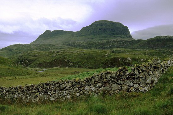
Suilven does not appear on any of the official lists - it is not a Munro
and is even well short of Corbett status. However it is one of the most
distinctive mountains in Scotland and is included on most lists of
'favourites', and many calenders, and should not be missed. Like all Assynt
mountains Suilven stands high above the surrounding land and, with the
characteristic buttress at the western end, it gives a sense of the impossible
when viewed from the Lochinver area. The isolated nature of the mountain also
adds to the sense of adventure needed to reach the summit - it is a long 6km
approach walk.
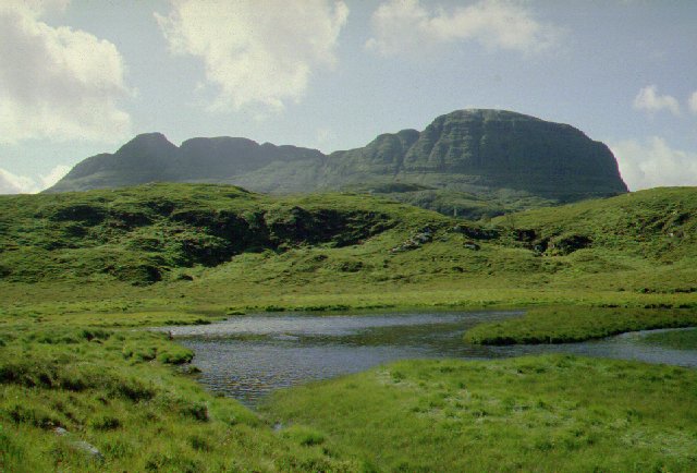
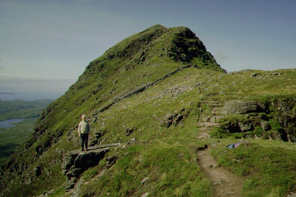
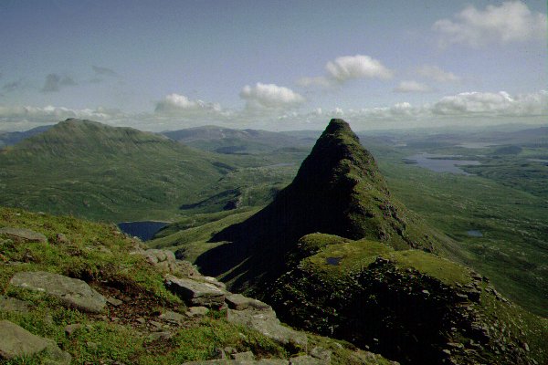
When seen in profile the true nature of the mountain is shown as a long
narrow ridge of three tops. The western top is the highest, and widest, and
surrounded by the characteristic buttress cliffs. The two eastern tops are much
narrower and, allegedly, provide good scrambling (we have never ventured along
them). There is an exposed ledge to be tackled on the climb to the most eastern
top that will deter many; some guidebooks list an ascent over the east ridge.
However the usual ascent is achieved by a climb to the obvious col to the east
of the main top.
Ascent Routes
There are two primary routes of ascent from the West: from Lochinver
along the Abhainn na Clach Airigh; or along the River Kirkaig
and around Fionn Loch. Both routes involve a long walk in of some 8km
although most of this is made on good paths. Both routes lead to the low col
Bealach Mor to the East of the main summit. Using both routes requires
transport between Lochinver and Inverkirkaig but would make for a excellent
round. Ascents from the East will be long and we have not considered them here;
a path runs from the Elphin to Ledmore Junction road.
 From
Lochinver take the narrow road East towards Glencanisp Lodge for 1.5
km. Just above Loch Druim Suardalam there is space for parking a few
cars; cars are not allowed further along the drive. The path passes behind the
house of Glencanisp Lodge and takes to the valley some half kilometre north of
the river; a sign forbids cycling along this path. The stalkers path is well
made and rises/falls over the hillside, however the valley is both broad and
carries only a shallow gradient. A path joins the route from
the Little Assynt to the north near the restopred bothy of Suileag (GR
148210). The path crosses the Abhainn na Clach Airigh by a bridge
a further 2km on. Shortly after this a cairn marks the point where the path is
left and you head south to the foot of the obvious col in the ridge of Suilven.
The path cuts across the peat hillside and is (usually) both soft and deep.
Pass to the west of Loch a' Choire Dhuibh to climb the steep and dirty
gully to the col at Bealach Mor.
From
Lochinver take the narrow road East towards Glencanisp Lodge for 1.5
km. Just above Loch Druim Suardalam there is space for parking a few
cars; cars are not allowed further along the drive. The path passes behind the
house of Glencanisp Lodge and takes to the valley some half kilometre north of
the river; a sign forbids cycling along this path. The stalkers path is well
made and rises/falls over the hillside, however the valley is both broad and
carries only a shallow gradient. A path joins the route from
the Little Assynt to the north near the restopred bothy of Suileag (GR
148210). The path crosses the Abhainn na Clach Airigh by a bridge
a further 2km on. Shortly after this a cairn marks the point where the path is
left and you head south to the foot of the obvious col in the ridge of Suilven.
The path cuts across the peat hillside and is (usually) both soft and deep.
Pass to the west of Loch a' Choire Dhuibh to climb the steep and dirty
gully to the col at Bealach Mor.
 From Loch
Kirkaig Where the road through Inverkirkaig crosses the River Kirkaig
there is a parking layby where cars can be left. A rough track starts on the
North side of the river, soon changing to a path as it climbs alongside the
river. The Falls of Kirkaig are passed
after approximately 3km. To reach Suilven the path continues and skirts behind
Fionn Loch - a route we have not explored - before also climbing to Bealach
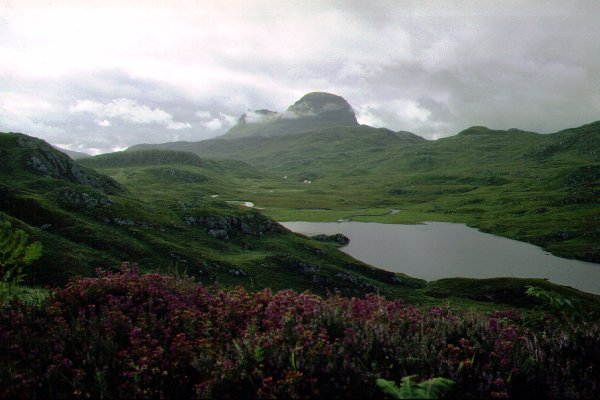
Mor. If you decide to visit just the Falls then it is worthwhile covering
the next 1km to view Suilven across the loch - one of the classic viewpoints in
Scotland.
From Loch
Kirkaig Where the road through Inverkirkaig crosses the River Kirkaig
there is a parking layby where cars can be left. A rough track starts on the
North side of the river, soon changing to a path as it climbs alongside the
river. The Falls of Kirkaig are passed
after approximately 3km. To reach Suilven the path continues and skirts behind
Fionn Loch - a route we have not explored - before also climbing to Bealach
Mor. If you decide to visit just the Falls then it is worthwhile covering
the next 1km to view Suilven across the loch - one of the classic viewpoints in
Scotland.
Our Expeditions
Our first expedition to Suilven was made by Susan (then aged 9) and
Simon. We were camping at the site in
Achnahaird (Achiltilbuie)
and drove the tortuous road to Lochinver first thing in the morning. We had
tried to start the walk the previous day but it was already raining heavily by
the time we were changing into boots and was clearly going to continue for some
time, so we retired to a cafe before returning to the site. This was now the
last day of the holiday and we were rewarded with a warm sunny day; Andrew and
Angela stayed at the site playing on the beach.
 The walk in
along the stalkers path was easy going - although Suilven looks along way off
when you start. The recent rain had swelled the river and lochans which, now
bathed in sunshine, gave a magnificent and ever changing prospect. We actually
missed (or rather failed to take) the path south and ended up at the bridge at
the start of Loch na Gainimh for a break before tackling the climb. By
now the mountain was in full profile filling the view to the South. Returning
to the marking cairn, the climb over the hillside was very wet and boggy where
the boots of walkers had broken the surface vegetation - just soft and wet
where this had not yet happened. The path climbs the hillside and passes to the
east of the first lochan Loch a' Choire Dhuibh before striking for the
foot of the gully. The ascent is not too high and although steep the col is
soon reached. We stopped for lunch here - perched on a rock overlooking the
steep southern slope just below the well built wall that crosses the ridge at
this point.
The walk in
along the stalkers path was easy going - although Suilven looks along way off
when you start. The recent rain had swelled the river and lochans which, now
bathed in sunshine, gave a magnificent and ever changing prospect. We actually
missed (or rather failed to take) the path south and ended up at the bridge at
the start of Loch na Gainimh for a break before tackling the climb. By
now the mountain was in full profile filling the view to the South. Returning
to the marking cairn, the climb over the hillside was very wet and boggy where
the boots of walkers had broken the surface vegetation - just soft and wet
where this had not yet happened. The path climbs the hillside and passes to the
east of the first lochan Loch a' Choire Dhuibh before striking for the
foot of the gully. The ascent is not too high and although steep the col is
soon reached. We stopped for lunch here - perched on a rock overlooking the
steep southern slope just below the well built wall that crosses the ridge at
this point.
 With the long walk in several
parties who had set off after us, or from the River Kirkaig path, now started
arriving on the ridge and there was quite a congregation on the summit by the
time we had started on again. The final climb gives an enhanced degree of
exposure as it passes through the gateway in the wall and ascends the large
rock blocks on the south side of the ridge, and then on to the main summit.
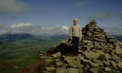
After the narrow ridge of the ascent the wide expanse of the summit is real
contrast and the various parties were able to spread out and take in the view
at their leisure. In common with all mountains in this region the view from the
top is far ranging and panoramic - virtually all mountains in the region can be
identified. Nearer at hand the expanse of moorland filled with lochans running
towards Lochinver reinforces the remoteness of the summit.
With the long walk in several
parties who had set off after us, or from the River Kirkaig path, now started
arriving on the ridge and there was quite a congregation on the summit by the
time we had started on again. The final climb gives an enhanced degree of
exposure as it passes through the gateway in the wall and ascends the large
rock blocks on the south side of the ridge, and then on to the main summit.
After the narrow ridge of the ascent the wide expanse of the summit is real
contrast and the various parties were able to spread out and take in the view
at their leisure. In common with all mountains in this region the view from the
top is far ranging and panoramic - virtually all mountains in the region can be
identified. Nearer at hand the expanse of moorland filled with lochans running
towards Lochinver reinforces the remoteness of the summit.
 We set off to pick our way
down the ridge and back to the bealach. A helicopter appeared and landed on the
summit - it had been taking photographs of waterfalls in the area and the
occupants fancied taking in a mountain top as well! Susan was obviously very
tired during the initial descent and we were pleased to regain the path in the
valley. We settled down to the long walk out taking advantage of the fine
weather through the long summer afternoon. We had offered a lift to two walkers
who had ascended by the southern route - they had explored the eastern end of
the ridge but soon caught us up and were waiting for us by the time we had got
back to the car.
We set off to pick our way
down the ridge and back to the bealach. A helicopter appeared and landed on the
summit - it had been taking photographs of waterfalls in the area and the
occupants fancied taking in a mountain top as well! Susan was obviously very
tired during the initial descent and we were pleased to regain the path in the
valley. We settled down to the long walk out taking advantage of the fine
weather through the long summer afternoon. We had offered a lift to two walkers
who had ascended by the southern route - they had explored the eastern end of
the ridge but soon caught us up and were waiting for us by the time we had got
back to the car.
Ever since Susan and Simon had tackled the summit in 1991 we had wanted
to visit the mountain again as the full party of four. Three years later we set
off along the stalkers path by Glencanisp Lodge; Andrew now aged 8 and keen to
tackle the high rocky ridge. The weather was overcast and although the mountain
tops were not covered, we received a major soaking in the 1hr 45min walk to the
start of the path across the hillside. The ground was much drier than on our
previous visit but was still wet and boggy in places; the path in increasingly
eroded by the number of visitors along this route. The gully to the bealach is
steep and eroding badly - a recent landslip making it very dirty underfoot.
 The ridge was easily tackled,
although airy and giving a good sense of exposure. Andrew thoroughly enjoyed
this and posed no problems to him. The wind dropped as we reached the summit
and a misty rain drifted over. We settled down for nearly an hour having lunch
- despite the midges that were a nuisance even at this height. Again we opted
to return directly and did not wait to explore the eastern end of the ridge -
another time perhaps. We kept moving on the long return path as the breeze was
not sufficient to clear the midges completely. The weather had not been at its
best yet we had a real sense of satisfaction at completing the expedition.
The ridge was easily tackled,
although airy and giving a good sense of exposure. Andrew thoroughly enjoyed
this and posed no problems to him. The wind dropped as we reached the summit
and a misty rain drifted over. We settled down for nearly an hour having lunch
- despite the midges that were a nuisance even at this height. Again we opted
to return directly and did not wait to explore the eastern end of the ridge -
another time perhaps. We kept moving on the long return path as the breeze was
not sufficient to clear the midges completely. The weather had not been at its
best yet we had a real sense of satisfaction at completing the expedition.
With the promise of a good walk if the weather was kind we included
another day on this mountain during a return holiday to the Far North in Summer
2001. Perhaps this year we would explore the western end of the ridge a bit.
The day dawned clear and we set off from Achnahaird along the Lochinver coastal
road to get a good start. We were walking by 10:30am - not bad - but cloud had
already started to obscure the tops of the mountains.
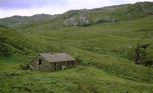
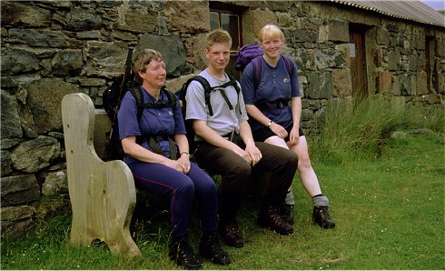
We had a quick peek at the Suileag bothy that lies hidden just off the
main path from Lochinver. The building has been recently renovated and offers a
good roof and sleeping platforms - the walls are pretty damp though. There is a
fine commemorative seat outside the front door giving a magnificent profile of
Suilven itself.
 We
continued along the long approach path with the cloud continuing to build up.
By the time we reached the point where the approach leaves the prepared path
and strikes out across the very wet and boggy ground to the foot of the main
climb, the clound level was well below the col. Having come so far we decided
to give it a bash and climbed up to shelter beside the short section of wall on
the col for a bite of lunch. We got odd glimpses of the valley floor below but
the weather continued to deteriorate. We were joined by a foreign tourist who
had decided to give the top a go - her friend had turned back on the final
climb and was waiting among the rocks at the bottom. It was very windy, we were
well in cloud and it was lashing with rain as we lifted our sacks for a final
clamber up the rocks to the summit. Under our encouragement to at least get to
the top having got this far our new companion came with us. Needless to say we
saw nothing from the top but we took the obligatory photograph of the cairn
anyway. We opted to give any further exploration of the ridge a miss - perhaps
next time.
We
continued along the long approach path with the cloud continuing to build up.
By the time we reached the point where the approach leaves the prepared path
and strikes out across the very wet and boggy ground to the foot of the main
climb, the clound level was well below the col. Having come so far we decided
to give it a bash and climbed up to shelter beside the short section of wall on
the col for a bite of lunch. We got odd glimpses of the valley floor below but
the weather continued to deteriorate. We were joined by a foreign tourist who
had decided to give the top a go - her friend had turned back on the final
climb and was waiting among the rocks at the bottom. It was very windy, we were
well in cloud and it was lashing with rain as we lifted our sacks for a final
clamber up the rocks to the summit. Under our encouragement to at least get to
the top having got this far our new companion came with us. Needless to say we
saw nothing from the top but we took the obligatory photograph of the cairn
anyway. We opted to give any further exploration of the ridge a miss - perhaps
next time.
We picked our way down and started on the two hour walk back to the car
during which time the skies cleared from the west and the cloud rolled back
from the tops. This was typical of the weather we encountered during this
summer - very frustrating. We called in for a rest and a bite to eat at the
bothy on the return leg. It had been a pleasant enough walk but we learnt
nothing new from the outing - except that Susan's new jacket purchased in
Lochinver was waterproof!
An alternative to the approach from Glencanisp Lodge is to use the
stalkers path from Little Assynt on the main road behind Lochinver - the
distance is about the same.
 It had been a grey
day with intermittent misty rain drifting in off the sea all morning. We passed
the time in Lochinver with Susan buying a new - and waterproof - fell jacket
and reckoned on a couple of hours walking before returning to camp via The Alt
for an early evening drink. We parked the car in a short layby just beyond
Little Assynt House and donned boots and jackets. A sign, Suileag 5km, points
aimlessly across a rough and wet pasture.
It had been a grey
day with intermittent misty rain drifting in off the sea all morning. We passed
the time in Lochinver with Susan buying a new - and waterproof - fell jacket
and reckoned on a couple of hours walking before returning to camp via The Alt
for an early evening drink. We parked the car in a short layby just beyond
Little Assynt House and donned boots and jackets. A sign, Suileag 5km, points
aimlessly across a rough and wet pasture.
The path varies between staurated bog and a good solid surface. The main
river is bridged but the next stream needs fording - this could be a problem
when the river levels are high. A prominent knoll is rounded and a high and
rickety stile has to be crossed in order to reach the flat and boggy open
hillside beyond. Gaiters were very much the order of the day to prevent
saturated trousers.
 The path aims for a low ridge,
rising steadily with a couple of zig-zags on the steaper section to cross a low
ridge and give an open view forward to Suilven - if we could see it! We had
been walking about 45 minutes and we were about half way to the bothy and the
main Suilven path. The approach path falls to pass beside three small lochans -
the bothy lies in a slightly sheltered hollow and was hidden from our current
position. Misty rain lingered everywhere and there was no view, so with little
incentive to carry on and lose height that had only to be retraced we turned
and returned to the car. As an alternative approach the distance involved is no
more or less, however the additional height gain and the rougher path would not
be a welcoming prospect on the long return from a walk to the summit of
Suilven.
The path aims for a low ridge,
rising steadily with a couple of zig-zags on the steaper section to cross a low
ridge and give an open view forward to Suilven - if we could see it! We had
been walking about 45 minutes and we were about half way to the bothy and the
main Suilven path. The approach path falls to pass beside three small lochans -
the bothy lies in a slightly sheltered hollow and was hidden from our current
position. Misty rain lingered everywhere and there was no view, so with little
incentive to carry on and lose height that had only to be retraced we turned
and returned to the car. As an alternative approach the distance involved is no
more or less, however the additional height gain and the rougher path would not
be a welcoming prospect on the long return from a walk to the summit of
Suilven.
References
- Although not a Corbett the mountain is included in the Guide to
the Corbetts by the SMC. It is also included in all guidebooks to this
area of Scotland as well as calendars and tourist literature.
- The Big Walks includes the east to west traverse from
Ledburg to Lochinver - including the direct ascent of the east ridge.
- Suilven also features in the video production The Munro Show
II by Muriel Gray.


