Beinn Uidhe
Introduction
Beinn Uidhe is a long, flat ridge of a summit that forms part of the extensive
ridge running to the east of the main road taking in Breabag in the south, Conival
and Ben More behind Inchnadamph in the centre and Glas Bheinn to the north.
Beinn Uidhe is not an obvious target to climb since, as already noted on other
pages, the long flat ridge is strewn with rocks and boulders. The summit ridge
is hidden from the main road running along the shores of Loch Assynt by the
shoulders of outliers. For lovers of dramatic scenery and solitude this area
is highly recommended. The tops are some 600ft (200m) lower than the more popular
Munro summits but here you are unlikely to meet anyone. For longer trekking
the paths extend to the north and west through some very remote terrain.
This section of the long ridge is well served by stalkers paths with branches
running to the cols to the SE (at Loch nan Cuaran) and to the NW (under Glas
Bheinn) making a traverse an obvious choice. Strong walkers would take in Glas
Bheinn and even traverse this to reach the road again at Loch na Gainmhich.
As this was a top not climbed previously - we made a day out of it.
Our Ascent
 In
2004 we had delayed our holiday until early September - now able to miss the
annual school holidays in England. The only drawback of this is that it gets
dark a good bit earlier than in the height of summer. This year we hit on a
week of fine weather and it was on a bright, sunny morning that we (just the
two of us) parked the car at the Inchnadamph Hotel car park, at the SE end of
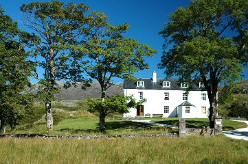
Loch Assynt. The track to the River Traligill (and caves) starts just across
the bridge and passes the rather impressive Inchnadamph Lodge - much improved
after renovation works.
In
2004 we had delayed our holiday until early September - now able to miss the
annual school holidays in England. The only drawback of this is that it gets
dark a good bit earlier than in the height of summer. This year we hit on a
week of fine weather and it was on a bright, sunny morning that we (just the
two of us) parked the car at the Inchnadamph Hotel car park, at the SE end of
Loch Assynt. The track to the River Traligill (and caves) starts just across
the bridge and passes the rather impressive Inchnadamph Lodge - much improved
after renovation works.
The approach starts by following the valley track - the approach to Conival
and Ben More - for the first 800m or so before striking off in a north easterly
direction up a steep grassy shoulder opposite an old footbridge. This path is
not walked heavily - most wlakers charging on up to the two neighbouring Munros
and leaving the large area to the north west well alone. We would not see another
soul all day long.
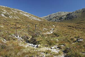
After an initial climb, and passing through an old iron gate (no fence wires
left - just a gate), the path contours as it traverses up the valley above the
Allt Poll an Droighinn. The main path is heading for Glas Bheinn so it climbs
north to cross the shoulder towards the high valley holding Loch Fleodach Coire.
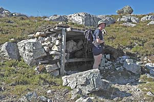
Before this is reached, a small seat and shelter has been built beside the path
- facing towards the hills to the NE. The intention is clear - the first to
return can sit and await his collegues in comfort. Just in front of this the
path divides (marked by a suitably modest cairn) with one route heading north
to Glas Bheinn, the other turning west towards the obvious col and (the hidden)
Loch nan Cruran. Water from the lochans above descends in gullies between the
steep cliffs to the south east - noisy and spectacular after heavy rain - and
the approach path makes an arc to the left to find an easier line of ascent.
The path to the west is not as clear as the northerly branch and some care
is needed in following it. After crossing the flat ground it starts a 600ft
(200m) ascent beside a small stream - the Allt Tarsuinn. At the 500m contour
the path turns right (SE) and takes a rising traverse below a line of crags.
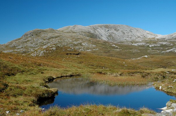
The path emerges at the side of the sizeable Loch nan Cuaran beside a large
boulder. The surroundings are dramatic - the main ridge forms a crest of broken
rock and grass at the far side of the water. To the right the ground rises in
long ridges to the heights of Conival - becoming increasingly broken and rock
strewn as they rise.
 It
is not clear as to the best way forward. The main ridge is still some 300ft
(100m) higher but as the top is wide and long the actual summit is not easy
to pick out (though it can actually be seen from here). The traditional approach
would be to strike to the lowest section of the col - on the far side of the
water - and gain the summit from there. This however takes in an extended length
of difficult terrain of broken rock and, as the summit to Beinn Uidhe is well
to the left (NW) a more direct route is a better bet. There is actually a very
faint path taking the shallow ridge to the north (NNE) - but we missed this
and ended up on the wide plateaux to the SE end some 1.5km from the true summit.
From here it is a long haul over very broken ground and hefty sized rocks. This
makes for slow going as you pick your way to the slightly raised summit knoll
and cairn (well plenty of rocks to make one).
It
is not clear as to the best way forward. The main ridge is still some 300ft
(100m) higher but as the top is wide and long the actual summit is not easy
to pick out (though it can actually be seen from here). The traditional approach
would be to strike to the lowest section of the col - on the far side of the
water - and gain the summit from there. This however takes in an extended length
of difficult terrain of broken rock and, as the summit to Beinn Uidhe is well
to the left (NW) a more direct route is a better bet. There is actually a very
faint path taking the shallow ridge to the north (NNE) - but we missed this
and ended up on the wide plateaux to the SE end some 1.5km from the true summit.
From here it is a long haul over very broken ground and hefty sized rocks. This
makes for slow going as you pick your way to the slightly raised summit knoll
and cairn (well plenty of rocks to make one).
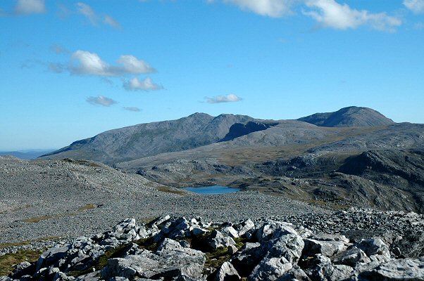
The views are, of course, extensive - particularly those to the North and East
looking out over some of the most remote terrain in Scotland - this takes in
Arkle and Foinaven, with Ben Hope and Ben Loyal on the skyline. To the NE Glas
Bheinn blocks out Quinag - with only the occasional top visible behind. To the
SW the immense size of the Conival and Ben More Assynt massif is clear. The
view to the South is into the sun and reveals unfolding ridges of the hills
through Assynt and Coigach.
To complete the traverse involves a further 2km of very rough ground - the
boulder field is unrelenting - before a modest descent to the path at the col
under Glas Bheinn. We took the easy option to return along the route we had
come up thus saving us 4km. From above it is easier to see the lay of the land
and we could work our way just above the southern escarpment making the most
of the strips of grass. This avoided the worst of the rough boulders but care
is needed not to lose too much height too soon as rising crags bar the way.

We eventually reached grassier ground above Loch nan Cuaran and as we picked
a way down we stumbled across the faint path - better late than never. As we
reached the lochside a four engined military plane roared overhead just clearing
the ridge. Clearly on some training exercise.
From here it is an easy going walk out being down hill virtually all the way.
We had not seen a soul and it was only as we reached the valley track beside
the River Traligill that we met parties returning from the big tops. We stopped
for a refreshing dip in the river before strolling the final few hundred metres
back to the car park. As usual we were the last ones off the hill.


