 Ascent
Routes
Ascent
Routes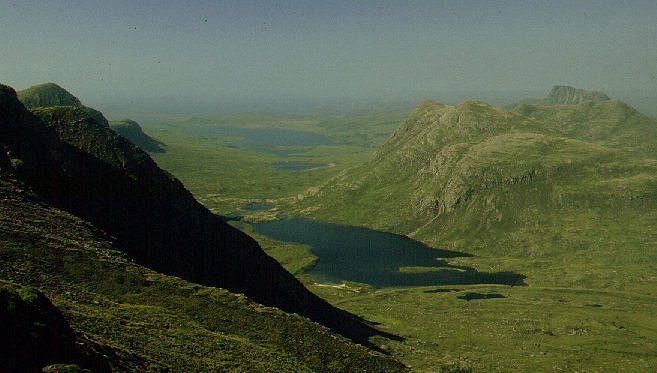
| Name of Tops: | Sgorr Deas Sgorr Tuath |
| Height: | 618m (2027 ft) |
| Map Reference: | OS Sheet 15; NC 138066 |
| Date of Ascent: | 2 August 1998 |
This twin topped mountain is technically an outlier of
Ben Mor Coigach but it stands
out so far that is half surrounded by Loch Lurgainn. By all
accounts it makes a pleasant outing over rough terrain that is rarely
walked and giving good views of the cliffs of The
Fiddler. We did not get around to tackling this summit until quite
late (1998) but if you collect the less popular tops then this is
definately one to put on your list. We did hear of the plans to forest the
slopes of this mountain and were fortunate to make this walk before the
work commenced. This will be the first major plantation in this district
and a step that will undoubtedly restrict the formerly free access to the
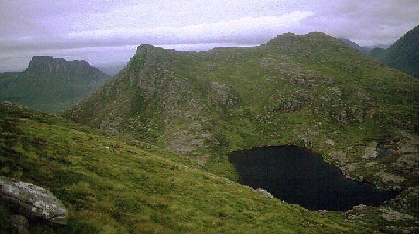
ridges. The view above is taken from the top of Ben Mor and shows the
double top of Beinn an Eoin above Lochan Tuath; the
mountain behind is Stac Pollaidh
- no prizes for that one!
Ascent
RoutesThe ascent route starts from the head of Loch Lurgainn, crossing the river by stepping stones. The day had been heavily overcast but showed some promise by late morning as we parked the car by the roadside. The path is very wet and boggy and follows on the south bank of the Allt Claonaidh heading towards Lochan Tuath. We crossed the river and cut across the rough heather to the foot of the slope under Cioch Beinn an Eoin. The end of the ridge is protected by a shallow line of crags so we struck a rising traverse up the steep slope to gain the ridge. It was still heavily overcast as we wandered back to the east end of the ridge but most tops were still clear.
It is an easy walk along the ridge climbing over a series of bumps to a
final pull up to the 618m top of Sgorr Deas. Here we stopped for
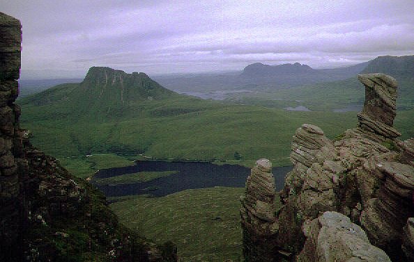
lunch directly opposite The Fiddler - the best views of the hugh cliff
face on this peak are gained by swinging south on the ascent or from the
valley path to Lochan Tuath. The central position of Sgorr
Deas gives clears views of all Coigach tops -all you need do is point
the camera and click the shutter.
A strong wind was blowing so we did not linger long before continuing
north along the ridge over a series of sandstone slabs, disturbing a herd
of deer that crossed to our right and disappeared over the shoulder. It is
a steep drop over grass and heather to reach the small lochan that nestles
in the col between Sgorr Deas and the next top Sgorr Tuath.
The climb beyond looks steep and craggy but is in fact fairly easy and
offers the opportunity of some simple scrambling - or just stick to the
grass. The top has a deep crack in the rock - wide enough to fall into if
not seen and deep enough to be difficult to get out of. The final stroll
east along the ridge is over sandstone slabs and boulders with some
pinnacles passed on the left. There is a clear profile view of
Stac Pollaidh seen across Loch
Lurgainn below.
 It
was now 4:00pm so we descended the grass and heather slopes to strike
across the wet valley floor to pass under the Cioch and regain the
path south of Feur Loch. The weather now closed in and it started
to rain as we drove along the road to the campsite at
Achnahaird. It continued to rain
for the next 16 hours!
It
was now 4:00pm so we descended the grass and heather slopes to strike
across the wet valley floor to pass under the Cioch and regain the
path south of Feur Loch. The weather now closed in and it started
to rain as we drove along the road to the campsite at
Achnahaird. It continued to rain
for the next 16 hours!
This is a mountain to return to when the skies are clear and blue as the views to the surrounding tops are most impressive - an ideal location for compiling a photographic record of the Coigach mountains.
As we discovered in 1998 the proposed forestry of the slopes has
commenced in the 1999 season. Over 30 miles of deer fencing have been
erected on the slopes of this mountain and planting of trees undertaken in
the spring and autumn of 1999. Access gates for walkers have been put in
at 'points commonly used for access' but we have not ventured into the
area since they appeared. The fencing will be left in place for around 10
years, by which time the trees will be large enough to withstand the deer
browsing the foliage - and the views across the valley will be very, very
different.
![]()
![]()
![]()