| Height: | 927m (3041 ft) |
| Map Reference: | OS Sheet 9; NC 478502 |
| Our Ascents: | 15 August 1993 |
Ben Hope is, by virtue of Foinaven's shortfall by a few inches, the most northerly Munro and therefore attracts more walkers than other mountains in this area. The mountain is conveniently placed near the road and many visitors approach from the south, often taking in Ben Klibreck to the south on the same day. When we visited we travelled from Durness in the north - a journey that took about an hour - and the mountain was still clad in cloud when we arrived. Starting the climb at 11:00 am we met several people already on their way down, they would have been off the mountain before the cloud broke to give a beautiful sunny and warm afternoon.
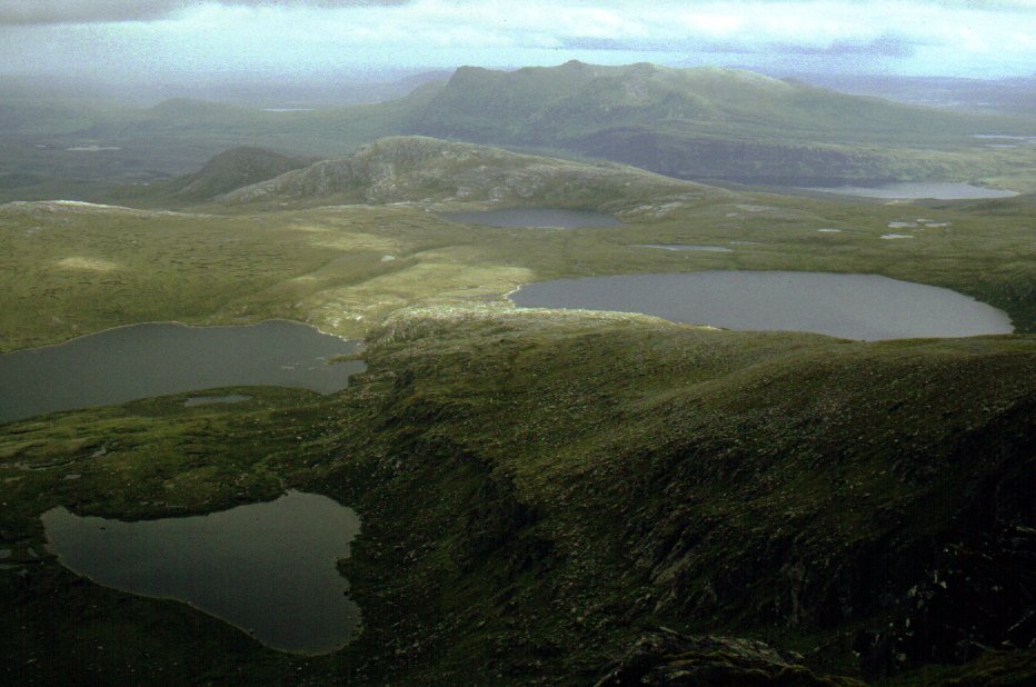
Getting to the foot of the mountain from the north west is somewhat circuitous - the road follows the shores of Loch Eriboll, a loch that stretches some 10km inland, only to turn south off the main road at Hope and follow the eastern side of Loch Hope a further 10km into the wide green valley of Strath More. The western side of Ben Hope is protected by two lines of cliffs that are at their highest in the north and falling steadily in height as you travel south. The main approach is from the south, usually gaining the long shoulder that runs right to the summit. The most southerly route begins at Altnacaillich, a few hundred metres north of the broch Dun Dornaigil; a path climbs beside the stream to gain the ridge Leither Mhuiseil and then follow the crest some 5kms to the summit. Two kilometres north along the road, opposite a barn, a path climbs beside a tumbling stream to breach the first line of cliffs and thus give a shorter means of attack.
From the more northerly starting point there is a choice of routes given in the guide books - continue northwards passing under the main cliffs to pass Dubh loch na Beinne and loop round to gain the base of the north ridge to the summit; alternatively follow a side stream that descends an obvious breach in the cliffs to gain the south ridge above. By either route the summit itself is found to be relatively open and flat, and sports both a cairn and a trig point.

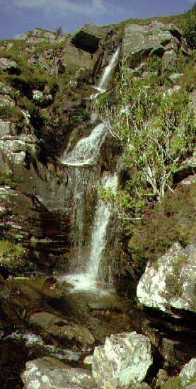
The forecast was for a good sunny day and despite the tops being well hidden under cloud we set out on the climb. We had toured over from Durness on the previous day but the combination of a late start and low cloud put us off - we explored the nearby broch and the Toungue area instead. You can park the car by the roadside right at the foot of the climb up the hillside; if you park on the opposite side of the road you more than double the length of the 'walk in'. The path climbs steeply beside the stream that falls over a series of cascades. The path is wet and boggy in places, particularly in the flatter area above the first shoulder.
There was a temptation to explore the northern ridge to the mountain, however it was obviously going to be a long and rough trek to get to the foot of the ridge and the guidebooks refer to a 30ft step high just under the summit itself (it can be bypassed by a grassy gully, they say). So instead we turned up the standard path to the breach in the cliffs above us, following the line of a stream up the somewhat steep and dirty path. It seemed a long haul up the 2km and 500m climb to the summit - probably due to the low cloud which hid the view throughout the climb on this section.
 As
we reached the summit the cloud started to clear and reveal the view given
by this high peak. An exploration of the north ridge reveals the grassy
gully that bypasses the bad step to be perfectly plausible as a route of
ascent (easier in ascent than descent) - perhaps next time. We waited
around on the top eating lunch whilst the cloud broke around us. We set
off to explore the tops to the east but the cloud suddenly closed in again
and we sought the safety of our ascent route. We need not have bothered
too much as the afternoon then steadily cleared and by the time we
regained the roadside it was a hot and sunny day.
As
we reached the summit the cloud started to clear and reveal the view given
by this high peak. An exploration of the north ridge reveals the grassy
gully that bypasses the bad step to be perfectly plausible as a route of
ascent (easier in ascent than descent) - perhaps next time. We waited
around on the top eating lunch whilst the cloud broke around us. We set
off to explore the tops to the east but the cloud suddenly closed in again
and we sought the safety of our ascent route. We need not have bothered
too much as the afternoon then steadily cleared and by the time we
regained the roadside it was a hot and sunny day.
This was our third Munro and gave an enjoyable day in the middle of what turned out to be a very wet holiday. The forecast was set fair for the next day so we returned to climb the neighbouring Ben Loyal; after this the wet and windy weather returned so we headed south to Achiltibuie but we were unable to tackle any high tops in the following four days.