| Height: | 911m (2999 ft) |
| Map Reference: | OS Sheet 9; NC 317507 |
| Our Ascents: | Southern Tops - 7 August 2001 Northern Approach - 10 August 2001 |
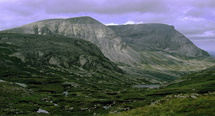
Foinaven is not really a single mountain, more a long high ridge over 5 km in length and taking in five major tops. The mountain has also been a 'borderline Munro' with occasional rumours that it has been reclassified as being above the 3000ft contour. However it is now confirmed as being just short of the magic figure and hence is not the Most Northerly Munro - yes the highest top is 500m further north than Ben Hope.
The ridge is made up of shattered quartzite and offers a long, high, steep and grey face to the main road on the west coast. The steep corries and side spurs that give the mountain its unique character are hidden on the eastern side. The quartzite screes are loose and steep and, apparently, shifting continually giving a constant background sound of tumbling rocks on a still day. Any ascent to the ridge and summit is a long day - the easiest approach being from the north; a full traverse is a major undertaking and will leave you back on a main road many miles from your starting point. Strath Dionard provides a convenient approach to the east side, leaving the A838 road at Gualin House and taking the track heading south east. This track has been upgraded to give a good hard surface and now extends as far as Loch Doinard (only shown on the newer OS maps). There is also a large 'No Cycling' sign nailed to the entrance gate discouraging the opportunity to ease the long approach walk. An alternative starting point is at the southern end of Loch Stack, following the approach to Arkle and then onto the southern end of the main ridge. A full traverse in either direction would make a very highly prized day walk - but does require return transport of some sort.
Given the magnitude of the outing to reach the summit this is the only major mountain in the north west that we have not had a go at. In 1993, when we were last in the area, we conquored the nearby mountain of Arkle and found this to be a long and arduous day - I reckon that an outing to Foinaven is about twice as long.
It was 2001 before we returned to the region to have a determined effort to get aloft the high ridges of the mountain. The weather was not at its best and we got only limited views of the ridges and long views. This does include a couple of Panorama Pictures taken from the southern end of the ridges.
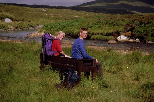
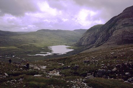
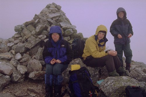
We had moved camp up to Scourie in order to be relatively near a start on this mountain in 2001. It was 10:00 am as we crossed the bridge at the south end of Loch Stack on the approach to Arkle and Foinaven. There was still a fair bit of cloud about but was reasonably bright and sunny - if a little breezy.
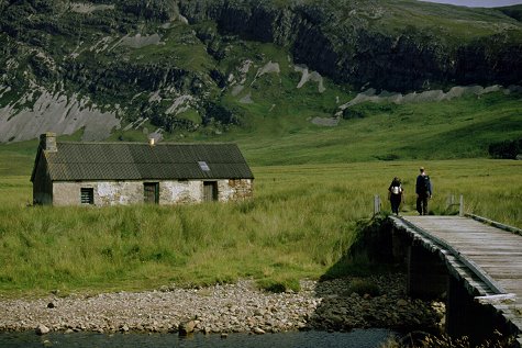
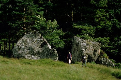
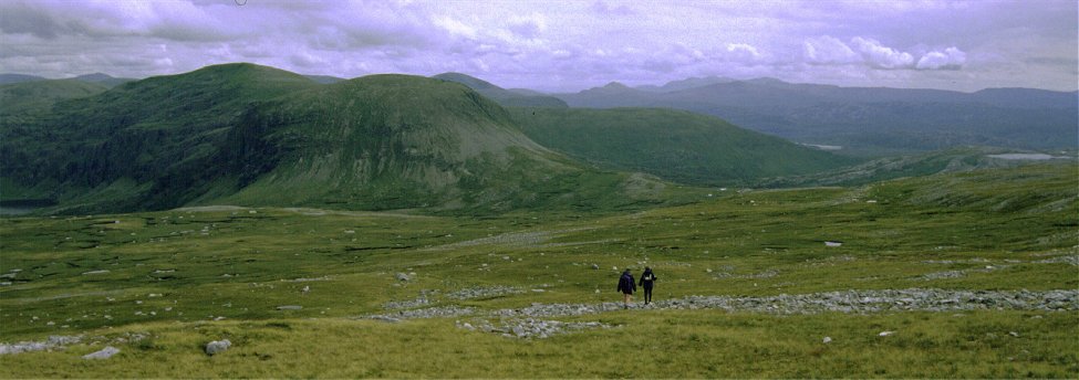
Rapid walking along the track took us to the old cottage at Lone within half an hour - this was all firmly locked up with little sign that it was open for use as a bothy. This point gives a fine view of the West face of Arkle. Here we took the path west, through the large split border and into the trees and then up a zig-zag path to climb the hillside into the hidden valley of Allt Horn above. There follows a long relatively flat section of path in the steeply sided valley before climbing the sides to clear a band of crags crossing the valley. The view is restricted to a backward glance to Quinag once sufficient height has been gained to see over the crags.
 Once the
shoulder has been gained the path drops slightly to cross the valley and turn
the col under Creagan Meall Horn. A brief glimpse of the ridge of
Foinaven is given when crossing the valley which is a bit boggy but the track
makes for easy walking. The path gains a height of 500m before swinging East to
reach Glen Golly. This route offers a number of possibilities for a
round walk, either take a path north towards Loch Dionard in Strath
Dionard (this will asmost certainly link up with the new track coming down
from Gualin House), or return West along tracks and paths between Shabal
Beag and Meall Garbh to return to the starting point, or continue
east to the road in Strath More near Ben Hope.
Once the
shoulder has been gained the path drops slightly to cross the valley and turn
the col under Creagan Meall Horn. A brief glimpse of the ridge of
Foinaven is given when crossing the valley which is a bit boggy but the track
makes for easy walking. The path gains a height of 500m before swinging East to
reach Glen Golly. This route offers a number of possibilities for a
round walk, either take a path north towards Loch Dionard in Strath
Dionard (this will asmost certainly link up with the new track coming down
from Gualin House), or return West along tracks and paths between Shabal
Beag and Meall Garbh to return to the starting point, or continue
east to the road in Strath More near Ben Hope.
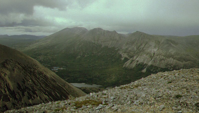
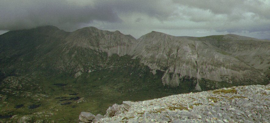
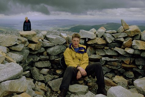
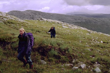
The high point of the track marks the starting point of the approach to the main ridge. The first top at 778m is seen to the right some two and a half kilometres away. The second top is slightly higher at 806 m is to the left, about one and a half kilometres from East of the first. A large herd of deer grazed the eastern slopes. We set off in a line towards the second top across a mixture of boggy grass, rock slab and shattered rocks and boulders. Picking the easiest line between the rocks was not easy from below and we then found our way barred by the crags above Coir a'Chruiteir. The easiest line is to take in the first top and we ended up swinging around the sides of the corrie on a grassy ledge - disturbing half a dozen deer at close quarters - in order to gain the ridge and finish on the modest slope to the second top.
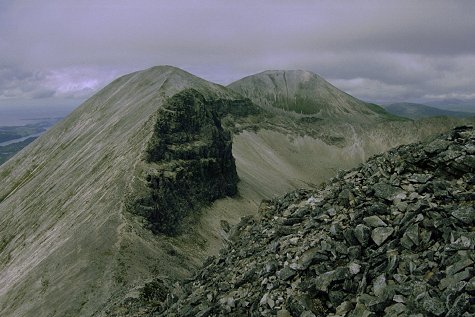
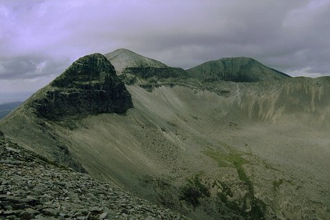
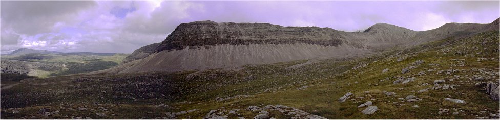
 Ahead
lies the central section of the Foinaven ridges. Beyond the initial steep drop
to the col a large black crag dominates the foreground. This is in fact
by-passed on the West by the ridge path to gain the next top at 867m. From this
point the long level ridge of A'Ch'eir Ghorm runs East at a right angle
to the main ridge. The ridge loses no height in a length over one kilometre,
grey/brown screes run below the crags to the valley floor and a prominent cairn
marks the sudden end to the ridge. Beyond the northern tops of Ganu Mor
drifted in and out of cloud. It was already past 2:00 pm - four hours walking
from the starting point - and it was too late to push on to the next summit and
return so we settled down for some lunch. Had the weather been fairer we would
have continued along the ridge but we were content to take in the extensive
view. Ben Hope, Ben Loyal, Ben Klibreck, Ben Hee, Arkle, Quinag, Suilven,
Conival and Ben More (Assynt), Ben More (Coigach) and An Teallach filled the
horizon. But what dominates is the ridges of Foinaven itself - the slopes
falling in continuous screes to the lochan filled plateau below. The long path
circling the Northern slopes of Arkle could be picked out far below picking its
way between the lochans.
Ahead
lies the central section of the Foinaven ridges. Beyond the initial steep drop
to the col a large black crag dominates the foreground. This is in fact
by-passed on the West by the ridge path to gain the next top at 867m. From this
point the long level ridge of A'Ch'eir Ghorm runs East at a right angle
to the main ridge. The ridge loses no height in a length over one kilometre,
grey/brown screes run below the crags to the valley floor and a prominent cairn
marks the sudden end to the ridge. Beyond the northern tops of Ganu Mor
drifted in and out of cloud. It was already past 2:00 pm - four hours walking
from the starting point - and it was too late to push on to the next summit and
return so we settled down for some lunch. Had the weather been fairer we would
have continued along the ridge but we were content to take in the extensive
view. Ben Hope, Ben Loyal, Ben Klibreck, Ben Hee, Arkle, Quinag, Suilven,
Conival and Ben More (Assynt), Ben More (Coigach) and An Teallach filled the
horizon. But what dominates is the ridges of Foinaven itself - the slopes
falling in continuous screes to the lochan filled plateau below. The long path
circling the Northern slopes of Arkle could be picked out far below picking its
way between the lochans.
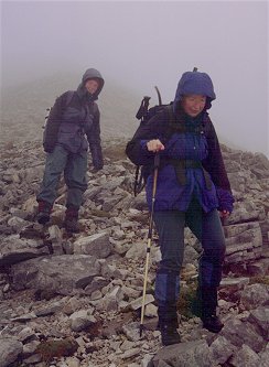
Learning from our mistake on the ascent we returned over the first top where a substantial shelter built from the ample stone lying about has been erected around the base of an old trig point. From here we descended the slopes picking a way through the rough stone on the grass wherever possible to reach the path at the col under Creagan Meall Horn. We had seen a couple of walkers ahead of us on the ascent, a group of three had been spotted on the main ridge and we were passed by a lone female walker on our descent. That was all we saw all day until nearly back at the car when we met a couple of cyclists. It is a long walk back out with the views disappearing as the track drops into the valley. In this instance it was uneventful and with the fast pace on the downhill track we reached the car just after 6:00pm, just as it started to rain. It had been a long day but worth it to get a good first hand view of Foinavens remarkable ridges.
This was the third outing to Foinaven's slopes within a week. On the previous day we had driven to Gualin House on the main road to Durness with the intention of exploring the northern ridges however the weather had been foul and we opted for something else instead (Ben Hee). We were back again on the last full day of the holiday in the hope of making a good day of it - a stiff breeze was blowing but as it was reasonably bright out to sea there was every chance the tops would clear. In event the cloud deepened encompassing the tops down to 500m.
The road around Gualin House was upgraded to loop behind the house and widened to two lanes - the only bit between Rhiconich and Durness. Parking off the road can be found 500m south of the house (at the north end of Loch Tarbhaidh) or 100m north of the house. Many walkers opt to take a direct line of approach across the wide expanse of wet and rough moor to tackle the slopes to the north top. Our choice was to use the new access track that runs from the house as far as Loch Dionard. It is a long track with a good surface - the estate bans the use of cycles though. The house and road are at the 200m contour whilst the flat river valley lies at only 80m - so the long walk in leaves you well below your starting point and leaves a sharp climb up again at the end of the day.
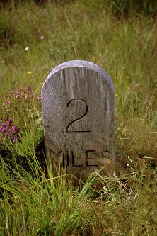
With the good surface (and down hill start) progress along the valley is crisp. Wooden 'mile' makers are posted along the side and all but one of the river crossings are bridged. A couple of huts (one more than shown on older maps) have been installed bu the estate for the convenience of fishermen - complete with rod posts to hold the fishing gear whilst a brew is being prepared.
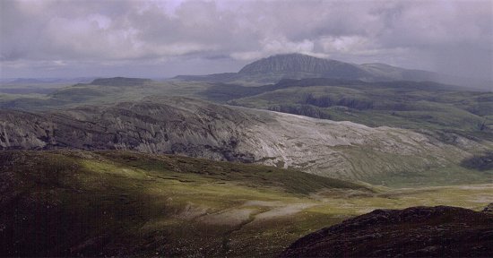
The long south ridge from Cranstackie runs the length of the valley and forms the eastern side. Our real starting point for the climb was opposite the southern end of Conamheall, just over one and a half kilometres from the loch. As we walked down the valley the first sight of the main tops that we got was the end of the long level ridge of A'Ch'eir Gorm. As the first oulier Cnoc a' Mhadaidh is rounded the high corrie of smoothed rock with the north east ridge of Ganu Mor high above makes an impressive sight.
The installation of such a well constructed track down this remote glen caused much controversy at the time. However the old line of the track can still be seen in the particularly wet and boggy areas and they still have not fully recovered several years on. Plastic sheet piles have been driven into the really wet and boggy areas to prevent wash out of the peat and encourage growth of cover. With modern demands on access the area would undoubtedly be a quagmire over great lengths without the new construction.
 Our
approach was to use the gentler slopes behind the rock face of Cnoc
Duail. At the five mile marker we donned gaiters and picked our way over
the higher hummocks to avoid the wet areas, climbing to turn the low ridge
running out to meet the track. We could still see nothing above the base of the
high ridges. Having turned the ridge we followed the side of the stream back to
its source, passing below the crags and screes of Cnoc a' Mhadaidh. We
made an easy climb over heather and rough ground to reach the wide col between
the main top of Ganu Mor and the low outlier of Cnoc Duail. Ahead
the terrain is steeper with 450 m of ascent in only 1500 m distance up steep
ground of rock and heather/grass. The steeper ground is to the right (nearest
the cliffs) and we made steady, if slow, progress upwards. The last craggy
outcrop is turned on the left on grass slopes to gain the foot of the scree
slope from the summit. The cloud had lifted steadily as we approached allowing
us to see our way and peer over the edge into the upper corrie on the far
(north) side of the ridge.
Our
approach was to use the gentler slopes behind the rock face of Cnoc
Duail. At the five mile marker we donned gaiters and picked our way over
the higher hummocks to avoid the wet areas, climbing to turn the low ridge
running out to meet the track. We could still see nothing above the base of the
high ridges. Having turned the ridge we followed the side of the stream back to
its source, passing below the crags and screes of Cnoc a' Mhadaidh. We
made an easy climb over heather and rough ground to reach the wide col between
the main top of Ganu Mor and the low outlier of Cnoc Duail. Ahead
the terrain is steeper with 450 m of ascent in only 1500 m distance up steep
ground of rock and heather/grass. The steeper ground is to the right (nearest
the cliffs) and we made steady, if slow, progress upwards. The last craggy
outcrop is turned on the left on grass slopes to gain the foot of the scree
slope from the summit. The cloud had lifted steadily as we approached allowing
us to see our way and peer over the edge into the upper corrie on the far
(north) side of the ridge.
This is the foot of the North East ridge to Ganu Mor, the highest of the tops, and we climbed into the cloud for the last 200m of ascent. With little visibility the climb seemed to go for ever - mainly over small rocks and stones but with a couple of sections of large boulders to be traversed. Suddenly Andrew declared the area 'toppish' and set off into the mist in search of the summit cairn. We noted the bearing of the ridge we had climbed and built a mini-cairn for back reference as the ridge we had climbed did not stand out in the mist. A second bearing was noted striking out across the flat top of the mountain.
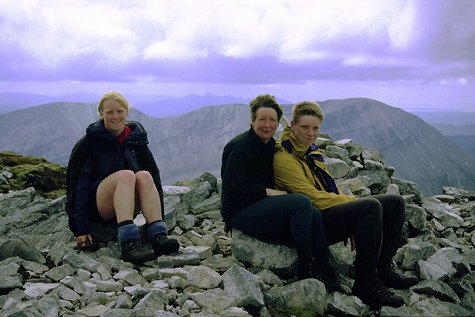
A large cairn appeared out of the mist - the top at last. The summit is long and flat and we wandered along to find a couple of walkers sitting beside a second cairn. They had not realised that there were two cairns and they opted to make sure of the true top by visiting both. We sheltered from the wind for a brief lunch break - now well past 2 o'clock. Although the sun tried to break through the mist nothing was revealled. After half an hour on the top we opted to descend by our route of ascent. Reversing the second bearing took us to our temporary cairn - which we demolished - we set the compass back to the first bearing and followed this back down the ridge. We came out of the mist at the foot of the ridge and we dropped down the next grass/rock slope taking a wider line to keep to shallower ground. Behind us the ridges and tops finally shed their shroud of cloud - one hour too late for us - very frustrating!
We were not returning up the slopes though - we still had substantial height to lose and a very long walk back to the car. As we descended a herd of over thirty deer passed below us heading for the high corrie. From our elevated position we could see a fairly easy descent into Coire Duail to reach the lower lochan of the two on this side of the mountain. We used deer paths and high hummocks where possible to miss the wettest of the sections. The track does hug the nearside of the valley side but it was still a hard slog to reach the hard surface. The descent gave good views back to the summit ridges and peaks - we also enjoyed good views over to Ben Hope to the east.
We reached the track at the four mile marker and shed waterproofs and gaiters in preparation to the long haul home. Again the tops clouded over. The two children started at a brisker pace and pulled out a half mile lead by the time we reached the two mile marker. The house and road still seemed a long way off and the rising ground imposing - if not depressing. However, the estate's all terrain vehicle came up behind us having collected a fisherman from the loch and offered us a lift. We clambered into the back and picked up the children further along the track. We settled down to enjoy the most fortunate ride back up the hill to the roadside - it was a real boon to the end of the day! This was followed by supper at Rhiconich and the next day we packed up and returned home. The weather had been far from perfect for the fortnight - with very frustrating levels of cloud hanging around the tops through the middle part of the days. It had been a good return to the Far North and we had thoroughly enjoyed our two ventures onto the high ridges of Foinaven.
We had started walking at 10:00 am and it had taken us two hours to reach the starting point of the climb. Even with the lift over the last part of the return trip it was past 6:00pm by the time we were back at the car - and this with no time on the ridge. Clearly a fuller tour of the mountain needs an early start and settled fair weather to make the most of it. The effort is well rewarded though.