| Name of Tops: | Sail Lath Sgurr Fiona Bidein a Ghlas Thuill |
| Height: | Sail Lath - 954m Sgurr Fiona - 1060m Bidein a Ghlas Thuill - 1062m |
| Map Reference: | OS Sheet 19, NH 069844 |
| Our Ascents: | 12 Aug 1999 |
An Teallach is rated as one of the classic mountains on the west coast of Scotland and offers a full and challenging day out for those who wish to explore its summits. The central ridge encompasses six main tops all over 950m in height (more if you include the intermediate ones on the south ridge) with two more outliers on the northern sides at the 800m level. The mountain is set back from the A832 coastal road and hides all its features when seen from the car driving north - well actually facing south east along the shores of Little Loch Broom. However when driving south along the road - yes actually facing north - and dropping down from the moorland into Dundonnell you can seen directly into the large eastern corrie with the pinnacles of the ridges on this side of the mountain clearly visible. It makes an inviting challenge.
The mountain sports two munros - it used to have only one but it was granted a second in 1981 largely, I suspect, because one seemed somewhat poultry for such a grand mountain. I reckon you could justify giving it six. Both munros can be conquered from the north without the need to traverse the southern ridge - but then you might as well sit at home and look at pictures as you miss all the fun.
An Teallach is somewhat isolated as it is a long way to Ullapool by road (only 10 km for a bird though), the vast expanse of Fisherfield Forest separates it from the Torridon ranges and the mountains of the Fannichs are further east. It was the discovery of a neat small campsite at Badrallach on the opposite shores of Little Loch Broom that opened up the opportunity to explore this classic mountain. The hotel at Dundonnell offering food and liquid refreshment was an added convenience. In 1999 we had completed a week on the Skye Cuillin, the weather had been dry and clear for days, and so we were fit and eager to take to the high ridges.
There are two popular approaches to the mountain, each having to cover 5 km or more from the road in order to reach the main ridge. Both munro tops are to the north of the pinnacles and so an approach from The Smiddy at Dundonnell is a commonly used route. This path ascends the shoulder of Meall Garbh on leaving the roadside and then traverses the wide open ridges of the northern slopes before ascending the main top if Bidein. As noted below this approach does not give you any views of the main ridges of An Teallach until the main summit is reached.
The second starting point is at Corrie Hallie and loops south to take a direct traverse of the central ridge in a south to north direction. This includes a traverse of several tops and, more crucially, the famous pinnacles. The approach does give excellant views of the mountain throughout the walk and leaves you thinking the path from Dundonnell is as dull as ditchwater. Importantly the pinnacles can be bypassed easily if you do not have the time or inclination to traverse them.
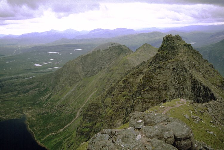
Guide books indicate that descents can be made over both the eastern ridges that surround Glas Tholl, Glas Mheall Mor and Glas Mheall Liath - these look decidely steep and uncomfortable. The route between them, through Glas Tholl, is the one we took for descent and is very pleasant. It is also safe in mist if you drop directly from the first col you reach walking north.
A visit to the main corrie and Loch Toll an Lochain is recommended in texts, taking the tourist path to the waterfall shown on the OS map and then following the river is the obvious approach. It seems possible to descend from the ridge by scrambling down one of the gullies to the north of Sail Liath, but it is obviously steep and loose and only of use if you traverse north to south.
With a long day anticipated on the mountain it was a determined effort for an early start. We had breakfast at the camp-site at Badrallach with sufficient breeze to keep the worst of the midges at bay. The morning breeze was, as had been for the past few days, still in the north east quarter so we could expect a dry and sunny, if cool, day on the hill. We parked at the roadside layby at Corrie Hallie and were walking by 9:10am. The first section of the walk takes the land-rover track that follows the course of the Gleann Chaorachain in a southerly direction through mixed woodland. As the track climbs you get a dramatic view of the ridge around Corrie Toll - particularly prominant are the pinnacles on the ridge.
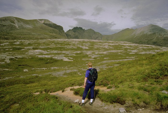
Just beyond the crest of the track a well marked footpath bears right on a slightly rising traverse across the broad shoulder of Sail Liath making, ultimately, to the bothy hut at Shenavall. The track has climbed steadily and has now reached an altitude of 400m - from a starting height of just 50m at the roadside. Opposite the shallow crags on the left a faint path veers off up hill in a rising slant across grass/heather slopes. As height is gained the ground becomes steeper and the path fainter - it is a slog of 400m to reach the head of the shoulder where the gradient finally eases. The views in the southern prospect open up dramatically as height is gained and, with the sun breaking through and enough breeze to disperse the midges, we changed into shorts and tee-shirts.
As the crest is approached the rock changes from sandstone to quartz blacks making progress on the steep ground more tedious. Several ptarmigan were running around between the rocks - they almost miraculously disappear every time they stopped moving so effective was their plumage camouflage. Once the gradient eased it was a steadier climb of 150m over the 700 metres to reach the summit cairn of the first top, Sail Liath. It was now 12:00 noon so we reckoned on a 4 hour window to complete the ridge around to the far munro top of Bidean. The breeze wass strong and cold so shorts were exchanged for trousers and fleeces donned. The pinnacles ahead looked much higher and imposing, with a long drop into the corrie below.
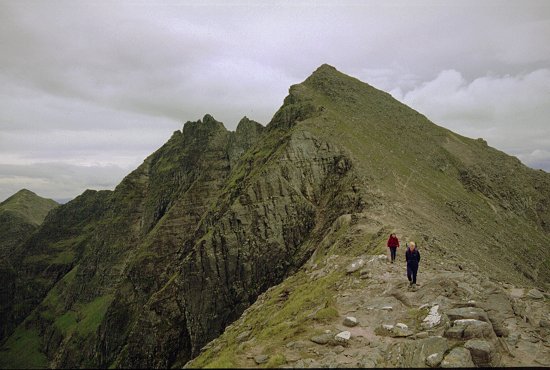
The route continues with a sharp drop and re-ascent to the next - more pointed - top. It is then down again and up loose eroded sandstone to the flat topped section of ridge before the pinnacles. From here we opted to crircle below the pinnacles taking an easy path on the south side that swings on a steep grass slope between gullies and around butresses. This is a real cheat as the main ridge offers some high class scrambling, however the bypass is much quicker to traverse and we wanted to be sure of getting off the mountain at a reasonable hour. We could explore these another day perhaps. A herd of wild goats were grazing on the slopes just below the path.
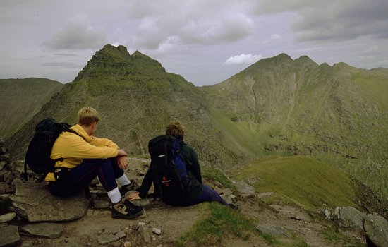
Once past the the main pinnacles we scrambled up the three hundred feet or so to reach the first munro top of Sgurr Fiona. It would have been worthwhile reversing part of the ridge to at least climb onto the last pinnacle, Lord Berkeley's Seat, however this did not occur to us until too late - no-one was going down again to reverse the section! The view was clear and widespread - from Ben Hope and Foinaven in the north round to Beinn Eighe in the Torridons to the south. To the east ran ridge after ridge of mountains. The neighbouring ridges of Beinn Dearg Bheag and Beinn Dearg Mor to the south look a most inviting pair for a day out. On the opposite side the drop to the corrie floor and Loch Toll an Locahin was steep, deep and dramatic.
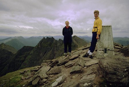
After a bite of lunch, and much studying of the views, the final leg of the ridge is a very sharp drop to the next col with a long pull up to the next (and marginally higher) munro top of Bidein a Ghlas Thuill; the 50 minute/1 km traverse was split equally between the time for the descent and the time for the re-ascent. This is the mountain's highest top and hosts a trig point as well as a large cairn. The standard ascent/descent path continues north over the wide flat ridges for some 2km before dropping down over a shoulder to the roadside at Dundonnell. In ascent this must be a most laborious and un-rewarding climb as it takes you over wide flat ridges and all views of the main ridges are hidden until the top is reached. The first descent is down loose sand and sandstone boulders - the path is cairned and picks a route that avoids virtually all boulder hopping.
We were aiming for the car so from the first col we made a sharp 50ft drop onto the steep grassy slopes of the upper corrie to Glas Tholl. The descent is essentially stepping down through the footholds made in the grass by previous walkers. The next drop into the main floor of the corrie is still grass, but somewhat steeper. Towering above on the right are the imposing crags of the east ridge of Bidean to the outlier Glas Mheall Liath. This is valley is somewhat attractive and far more interesting to walk down than the map indicates.
A faint path follows the valley keeping to the north (left) side of the stream. Springs from the underlying sandstone feed the burns so there is more water about here than the dry weather of the past few weeks would lead you to expect. The path is largely over peat ground and makes pleasant and soft walking - it is however starting to get heavily eroded through use and is likely to deteriorate in coming years. After a series of steeper drops down the hillside you reach a waterfall and a tourist path that descends the last kilometres over rock slabs to reach the road. The final two hundred metres pass through trees and rhododendrons with the latter completely overgrowing the path - you have to tunnel your way through like a Himalayan jungle.
It started to rain as we reached the road and walked the short distance back to the layby. We completed the walk at 6:00pm. Time for a drink and a meal.
This walk was undertaken on the Thursday of our second week on the west coast of Scotland. It had been dry and sunny - if a little chilly and midgy - for our entire stay. The rain that started as we returned to the car was the first we had seen and as we sat in the hotel for supper we saw the weather forecast. The winds had changed from the north east where they had been for days and were now south westerly bringing with them plenty of rain. It was agreed to settle up for the week and return home the next day. It had been an outstanding fortnight and no-one fancied a walk in the wet, or a day playing 'tourist', just to fill out the remaing day.
![]()
![]()
![]()