| Name of Top: | Beinn Ghobhlach |
| Height: | 635m |
| Map Reference: | OS Sheet 19, NH 056943 |
| Our Ascents: | 27 Jul 1998 |
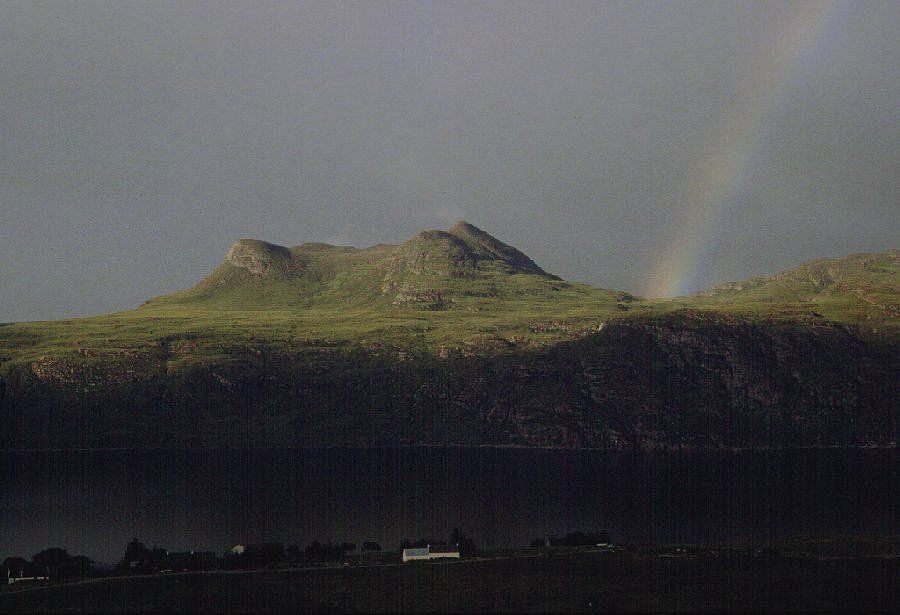
This mountain stands out on the Scoraig Peninsula that separates Little Loch Broom from Loch Broom and is isolated from the main mountains. However it offers a well developed double topped ridge when viewed over the water from the Dundonnell road and its location promises an impressive viewpoint.
 It is a long drive to
Dundonnel from Gairloch but the reckoning was that this mountain would stay
clear of the cloud, whilst its near neighbours around An Theallach would remain
shrouded. You leave the main road at the head of Little Loch Broom and the
single track road weaves between mature tress as far as the lodge before
climbing the hillside to the col above Altnaharrie, then drops back to the
shore at Badralloch. There is a campsite here - it claims to be a 'Camping
and Caravan Site' although the signs at the start of the road proclaims
it to be 'Unsuitable for Caravans'. Had we known we would have brought our
tents with us and saved a long drive back in the evening.
It is a long drive to
Dundonnel from Gairloch but the reckoning was that this mountain would stay
clear of the cloud, whilst its near neighbours around An Theallach would remain
shrouded. You leave the main road at the head of Little Loch Broom and the
single track road weaves between mature tress as far as the lodge before
climbing the hillside to the col above Altnaharrie, then drops back to the
shore at Badralloch. There is a campsite here - it claims to be a 'Camping
and Caravan Site' although the signs at the start of the road proclaims
it to be 'Unsuitable for Caravans'. Had we known we would have brought our
tents with us and saved a long drive back in the evening.
There is now no regular passenger service over Loch Broom from Ullapool - although the hotel launch may be able to offer a lift - and this leaves a 6km walk (and a 230m climb) to Badralloch. The road route from Ullapool is long as it goes via Corrieshalloch and Braemar junction.
There is space for a few cars at the road end from where an excellant path follows the hillside above Little Loch Broom. The An Teallach massif across the loch was well under cloud although its western outlier, Sail Mhor, looked as though it would break free. The path continues to Scoraig at the end of the peninsula traversing the southern and eastern aspects of Beinn Ghobhlach. Most guides give a route that climbs the steep grass/crag hillside at the first opportunity aiming just west of the crag carrying a 338m spotheight. This however misses the best part of the prepared path as it climbs higher under the crags - complete with handrail and small gate. You end up well above the shore with an excellant view ahead of the lower peninsula.
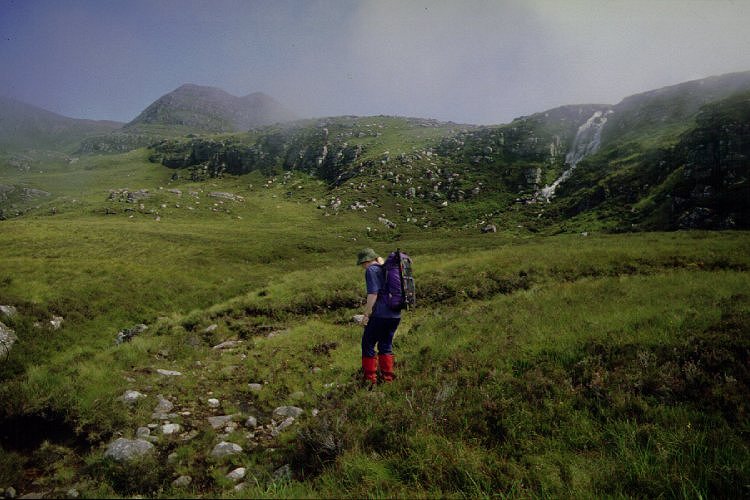
 At the first stream we left
the path and climbed the steep heather slope beside the first waterfall - the
direct route was steep and wet but easier ground is found to the left. After
all the rain of the summer the falls were full and spectacular - above the
first fall is a second with three more ahead. By crossing the stream a couple
of times we could keep to the easier slopes as we climbed to the hidden Loch na
h-Uidhe. A pair of eagles soared calling overhead, there were ravens about and
we disturbed several newts in the grass. There is no path - perhaps a suspicion
in places - and despite the large volume of water on the falls the stream
narrowed in places and could be stepped across (or jumped for those with
shorter legs).
At the first stream we left
the path and climbed the steep heather slope beside the first waterfall - the
direct route was steep and wet but easier ground is found to the left. After
all the rain of the summer the falls were full and spectacular - above the
first fall is a second with three more ahead. By crossing the stream a couple
of times we could keep to the easier slopes as we climbed to the hidden Loch na
h-Uidhe. A pair of eagles soared calling overhead, there were ravens about and
we disturbed several newts in the grass. There is no path - perhaps a suspicion
in places - and despite the large volume of water on the falls the stream
narrowed in places and could be stepped across (or jumped for those with
shorter legs).
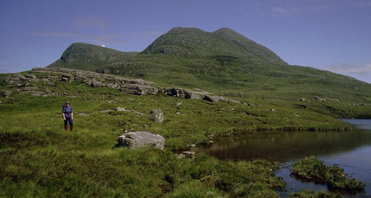
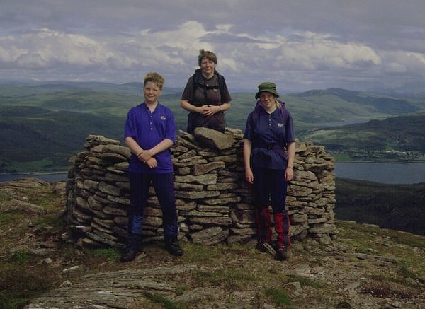
The final fall is the outfall from Loch na h-Uidhe and the slopes of the main top could be seen rising behind - now clinging on to just a few shreds of fluffy cloud. We decided to walk over the north side of the loch then strike up rising grass/heather to the foot of the slope to the obvious col on the ridge above. We stopped for lunch on a large sandstone outcrop looking out over Little Loch Broom below. From here it is a 30 minute climb to the col, plus a 10 minutes to the summit. There is a neat cairn and a large well built shelter - the area is clean indicating the lack of visitors who make it to this peak. As anticipated there is a fine 180 degree panorama including the islands of Loch Broom, the Coigach and Assynt hills, and Ullapool far below. The sea had a covering of low cloud and the onshore breeze was bringing it up the Loch, the islands were acting as barriers holding back the cloud resulting in long fingers of cloud drifting landward through the larger gaps. To the south An Teallach was still well in cloud - our reasoning had been sound and we were duly rewarded with a memorable climb.
 After studying
the view with the aid of a 1/4 inch map (yes one of those old ones - the roads
aren't right and the heights are in feet but the mountains haven't moved and
there is nothing better for identifying the skyline and it is a calm day) we
took to the ridge circling Coire Dearg. This takes you over the northern ridge
which sports 1000ft cliffs and steep ground falling directly into Loch Broom.
From the final top, sited squarely against the long ridge of Ben Mor Coigach to
the north, we dropped down easy slopes into the upper coire. The descent
continued to the high plateau over grass and heather, followed by flatter - and
wetter - ground to the head of the final slope. Here the stream, nowhere as
large as the one we had climbed beside, tumbled over falls in a final 600ft
drop to the shore. Before regaining the main path we rested and showered in the
fast cold waterfalls, from where it was an easy stroll back around the cliffs
(watched by an inquisitive seal) to the car.
After studying
the view with the aid of a 1/4 inch map (yes one of those old ones - the roads
aren't right and the heights are in feet but the mountains haven't moved and
there is nothing better for identifying the skyline and it is a calm day) we
took to the ridge circling Coire Dearg. This takes you over the northern ridge
which sports 1000ft cliffs and steep ground falling directly into Loch Broom.
From the final top, sited squarely against the long ridge of Ben Mor Coigach to
the north, we dropped down easy slopes into the upper coire. The descent
continued to the high plateau over grass and heather, followed by flatter - and
wetter - ground to the head of the final slope. Here the stream, nowhere as
large as the one we had climbed beside, tumbled over falls in a final 600ft
drop to the shore. Before regaining the main path we rested and showered in the
fast cold waterfalls, from where it was an easy stroll back around the cliffs
(watched by an inquisitive seal) to the car.
We had started walking at 11:10 and returned to the car at 6:00 - although several parties had walked the coastal path we had seen only one person (in the distance) on the hill itself. We stopped for supper at the Dundonnell Hotel before driving back to Gairloch with the evening sun shining on the northern hills. Finally the cloud returned bring back the rain that so dominated the summer of 1998.
![]()
![]()
![]()