| Name of Top: | Seana Bhraigh |
| Height: | 927m |
| Map Reference: | OS Sheet 20, NH 282879 |
| Our Ascents: | 2 August 2000 |
This munro top is one of the more remote being situated deep between the Inverlael Forest and Freevater Forest regions west of Ullapool and many miles from the nearest approach roads. A notice on the track in Strath Mulzie at the house just short of Corriemulzie Lodge (NH 328 954) says that walkers cars should be left here - so access can be gained from Oykel Bridge via Duag Bridge. This still leaves a considerable walk in along the upper reaches of Strath Mulzie to Loch a' Choire Mhor where the start of the climb proper begins. Mind you with the loch sited at the 300m contour virtually one third of the mountain has been climbed by the time this point is reached, and as the track has a reasonable surface a cycle can be taken all the way there.
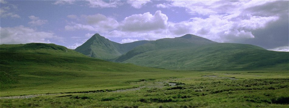
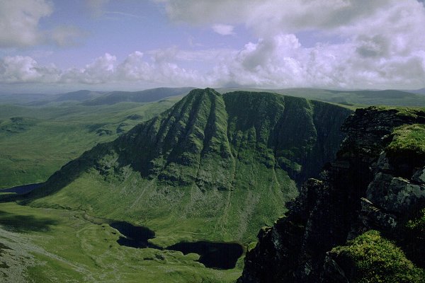
Although the approach walk is a long one the northern profile of the mountain against the skyline is both dramatic and enticing. To the left is a sharp conical summit with an obvious and steep ridge running down towards you. This shapely peak looks to be actual summit - it deserves to be - however this is the secondary top of An Sgurr (just north of Creag an Duine marked on the OS map). This peak is no more than 20m lower than to true summit, Seana Bhraigh, which lies one kilometre west on the rounded hump of the main mountain mass. These two tops are the western end of a long high ridge that runs over 5km in an east to west line offering a long wall of cliffs that form the southern side of Coire Mor. The upper reaches of this glen are hemmed in by these slopes making any traverse east to the next valleys arduous and without an obvious approach. However, a circuit around the rim over the shoulder of Carn Ban (NH 338876) would make a tremendous, if arduous, outing.
With the high cliffs all round, and the sharp spur rising directly behind the loch, the upper valley of Coire Mor is both extremely secluded and highly dramatic. By the lochside is the equally remote bothy which, as it is sited right at the foot of the mountain slopes, can be used as a sort of advanced base camp . We used this facility in August 2000, walking in from Ullapool along Loch Achall and using the paths and bothies in the area for a four day back-pack. Being well away from the usual tourist routes the area is remote and wild - we saw no other walkers in the area at all and this was at a prime holiday season.
 We had found copies
from a mountain guidebook in the bothy which detailed the various options of
ascent for Seana Bhraigh . The most obvious, and the most dramatic by a good
way, is a direct ascent of the steep ridge to the secondary peak of An Sgurr,
then a clockwise circuit above the upper corrie and the small Loch Luchd Choire
to take in another top, Creag an Duine, before reaching the true summit. Return
and descent is made by the easier slopes on the north west side. The ascent has
to cross a series of crags as height is gained, however the guidebook reassures
that these can be traversed without too much difficulty.
We had found copies
from a mountain guidebook in the bothy which detailed the various options of
ascent for Seana Bhraigh . The most obvious, and the most dramatic by a good
way, is a direct ascent of the steep ridge to the secondary peak of An Sgurr,
then a clockwise circuit above the upper corrie and the small Loch Luchd Choire
to take in another top, Creag an Duine, before reaching the true summit. Return
and descent is made by the easier slopes on the north west side. The ascent has
to cross a series of crags as height is gained, however the guidebook reassures
that these can be traversed without too much difficulty.
When we got up on the Wednesday morning the corrie around the bothy was
filled with mist and although there was a clear blue sky above it was taking
quite a time to lift. We were keen to make a start as we were intending a
reasonable quick ascent and return, then shoulder the main packs and walk back
to the bothy at Knockdamph. With the obvious steepness of the direct assault,
and our reluctance to undertake this in mist, we opted for the easier route up
the grassy slopes to the main summit.
The bulk of our gear was packed into stuff sacs and two of the larger rucksacks and we set off across the outfall of the loch with just two light packs holding drink, a bit of food and waterproofs. A sizeable burn comes down from the loch high above and the water was clear and cold - without the brown colouring of the stream behind the bothy. We filled the water-bottles before making our way up the slope to the lip of the upper corrie.
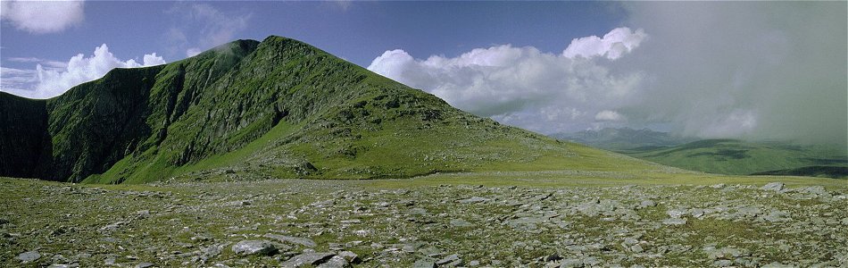
We aimed a diagonal climb up the steep grassy slopes, ensuring we bypassed the crags that form the northern end to the ridge above. The slope was covered with grass and bilberry - an ample supply of berries indicating that the season obviously suited the fruit. It was a long haul up to the open crest above - having got used to the valley walking the exertions caused much huffing and puffing - and a fundamental questioning of why we bothered to do this at all. As the ridge was gained the sun and breeze started to lift the mist from the surrounding ridges and tops. The route now turned south west following the broad ridge over two smaller crests to reach the wide open expanse of the first top - just clearing the 750 metre contour. It was then an easy stroll forward to the side of a small lochan that nestles under the final climb of 175 metres. Just to the right of the summit shoulder (WSW) the tops of An Teallach were already clear and bathed in sunshine.
 After a
quick rest and bite to eat we dropped to two sacks and climbed the easy, but
again steep, grassy slopes to the wind shelter on the summit. The top is sited
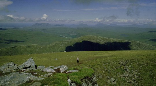
right above the cliffs that fall to Loch Luchd Choire below. By now the West
Coast was virtually clear of cloud - the Torridons, An Teallach, Coigach (in an
unusual view from the East), Assynt and beyond were all laid out along the
horizon. Beinn Dearg is much nearer (7 km) to the SW and still had large
patches of snow on it's northern slopes. Ben Wyvis lies to the SE - a large
rounded massive when seen from this distance and direction.
After a
quick rest and bite to eat we dropped to two sacks and climbed the easy, but
again steep, grassy slopes to the wind shelter on the summit. The top is sited
right above the cliffs that fall to Loch Luchd Choire below. By now the West
Coast was virtually clear of cloud - the Torridons, An Teallach, Coigach (in an
unusual view from the East), Assynt and beyond were all laid out along the
horizon. Beinn Dearg is much nearer (7 km) to the SW and still had large
patches of snow on it's northern slopes. Ben Wyvis lies to the SE - a large
rounded massive when seen from this distance and direction.
As we sat taking in the panoramic view the sun disappeared behind the cloud for a while and the air soon turned chilly. We had already decided that we were going to descend by our route of ascent and we quickly dropped back down the mountainside. Perhaps we should have explored the top a bit more - although no-one was keen on a descent by the ridge under An Sgurr opposite. However it had been decided that we wanted to walk out of the valley that afternoon - the sheltered corrie whilst picturesque in the extreme was an unfortunate haven for midges making the prospect of sitting outside in the evening unbearable. With under 3 km horizontal distance and some 600m of descent it did not take long before we were back on the lower slopes and beside the burn again - time for a refreshing 'shower' before strolling back to the bothy to collect our gear. We had seen a party of vehicles drive up the valley and found a family picnic/BBQ and fishing party in full swing. We were offered freshly caught and cooked trout to accompany our usual soup and nibbles before shouldering our sacks for a long (and hot) walk down the valley.
Return to Glen Achall Walk - Day
4
Glen Achall Walk -
Start
Most guide books describe the appraoch to this peak from Inverlael to the west - for the sole reason that this is the shortest route to 'bag' the summit and return. This (as the accounts all acknowledge) misses the prime attraction of the mountain as the northern aspect of the peaks and cliffs are completely hidden from view. This approach also requires careful navigation over the final stretch as the stalkers path does not complete the traverse of the intervening ridges.
![]()
![]()
![]()