
| Name of Top: | Am Bodach | Sgorr an Iubhair |
| Height: | 1032 m (3386 ft) | 1001 m (3284 ft) |
| Map Reference: | OS Sheet 41; 176651 | OS Sheet 41; 165655 |
| Our Ascents: | 13 July 2002 | |
These two tops lie in the centre of the Mamore ridge at the head of Allt Coire a'Mhail that cascades over the Steall waterfall in Glen Nevis. Although these tops can be included in the 'round' from Glen Nevis (the 'Ring of Steall'), they can be tackled easily from the south using the stalkers paths.
For Munro baggers Am Bodach is listed as a member of the 3000ft and higher mountains. However the second summit listed here, Sgor an Iubhair, was only promoted to Munro status in the 1981 Edition of the list. Since then opinion has changed again and it has subsequently been demoted as it is considered to have too small a height separation from its higher neighbour when compared with other Scottish mountains. So, some may say there is no need to climb this one. But there again, who is not to say that the list will not be changed again in the future.
We has stopped for the night at the Mamore Lodge prior to spending a few days in the Grey Corries and Corrour area. Rather that just rush off into the wilds we decided to spend the first day of the 2002 holiday having a return trip to the Mamore ridges. We had previously visited most of the tops at the eastern end of the ridge, so we looked to the west. Am Bodach we had seen before from our walks to Na Gruagaichean but not climbed, so this was picked as our prime target for the day.
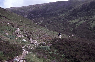
The days starts with a pleasant stroll of 1.5km along the track from Mamore high above Loch Leven and the village. Being the start of the day a long string of walkers were ascending the path from the village on their way to Fort William and the end (we assume) of their walk. One of the student groups was singing. The waymarked path, the West Highland Way, joins the track just after the mobile telephone mast but it is little more than a couple of hundred metres beyond this that the stream draining the corrie between Am Bodach and Stob Coire na h-Eirghe is crossed by a wooden bridge. On the far (west) bank of the stream a path leaves the track and climbs through the heather heading up into the higher valley - leaving the many groups to their long (and hard - underfoot) walk to their goal. We refilled the waterbottles before heading off towards our own goal.
The path is easy to follow as it climbs steadily above the stream. From below the upper corrie is hidden as the valley swings to the west, but views to the south, over Loch Leven to the Gen Coe ranges open up as height is gained. As we drew under the outlier crags to Stob Coire na h-Eirghe we could see a pair of Golden Eagles soaring high over the ridges.
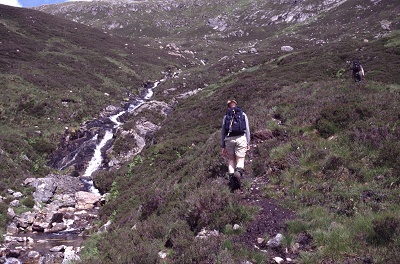
The path crosses the stream higher up where we rested for a drink, and also caught up with the only other walker we saw on this ascent. Beyond the path continues on a steady climb towards the ridges. Short of the col it turns right, towards Am Bodach, and zig-zags up steeper ground to gain sufficient height before swinging back left on a final, and much gentler, run to the col between Am Bodach and Sgorr an Iubhair. This line of approach, with the paths reaching the cols at a very gentle angle, is common in the Mamores and makes for very pleasant climbing - it ensures you are not completely breathless as you reach the end of the climb. From the col we were rewarded with a wide view of the other Mamore summits.
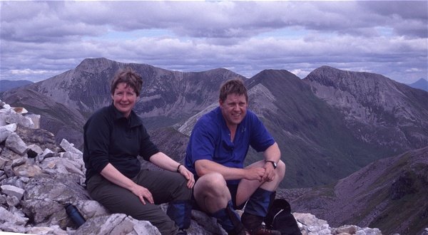
By now the skies had cleared and a sunny panorama of the Mamore ridges, with the Nevis mountains and the Grey Corries, was laid out before us. We could see to the horizon. Behind us, the ridges around Bidean on the south side of Glen Coe could be seen above the tops of the north Glen Coe ridges. It had taken us two and half hours to complete the climb and we rested for a while taking in the view. The West Coast of Scotland had been experiencing a prolonged period of rain and cloudy weather for some weeks and we knew we were extrememly fortunate to have the opportunity for some excellant weather.
Am Bodach had been set as the first target so we set off up the rising and steepening ridge to the main top. The summit has a slightly flat top with a large cairn towards the southern end. The main ridge continues NE, dropping down a very steep ridge to the next col. To the South East steep cliffs fall far to the corrie below. Peering over the edge we again saw the pair of eagles (we assume that this was the same pair) gliding in and out of the cliffs, hanging on the rising thermals - their actions attracting the mobbing of half a dozen ravens. We watched them for several minutes before settling down for lunch, stretched out in the sun, admiring the wide view.
From this top there are a couple of options. You can continue east over Stob Coire a' Chairn and pick up another path below Na Gruagaichean that descends to the Allt Coire na Ba, just east of the starting point at Mamore Lodge. Or return west to the col and continue over Sgorr an Iubhair. We opted for the new (to us) territory and dropped back down the ridge. The climb to Sgorr an Iubhair is lower, but being significantly nearer, it is a good bit steeper although there are no difficulties. We were soon sitting on top of our second 1000+m top of the day. [This top is listed at 1001m, and remember we started at Mamore which is already 200m up, but the statement is technically correct and looks impressive!]

There was by now a cool breeze blowing but the skies were still sunny and clear. The main circuit of the corrie (the 'Ring of Steall') now turns north over the Devils Ridge to the northern outlier of Sgurr a' Mhain. From our vantage point the Devils Ridge looked obviously narrow, but there appeared to be no real difficulties involved in a traverse. The main Mamores ridge continues west, with a long drop to 750m before the re-ascent to Stob Ban - at virtually the same height but missing the all important 2m to be listed at 999m. The map shows a further path dropping SW from the col below Stob Ban, heading for the old ruin at the highest point on the West Highland Way path - although the last part of the descent is pathless.
 Alternative descents can be achieved along the south ridge towards
Stob Coire na h-Eirghe - again a pathless descent over steep heather. We opted
for the easiest option of all, taking the grassy slopes of the south ridge for
a few hundred metres, before turning east back on ourselves on a path that
skirts under the main top to reach the head of the col from our original ascent
- this route avoiding the steep descent required by a direct return to the
col.
Alternative descents can be achieved along the south ridge towards
Stob Coire na h-Eirghe - again a pathless descent over steep heather. We opted
for the easiest option of all, taking the grassy slopes of the south ridge for
a few hundred metres, before turning east back on ourselves on a path that
skirts under the main top to reach the head of the col from our original ascent
- this route avoiding the steep descent required by a direct return to the
col.
We returned down our route of ascent - sharing the path with another pair of walkers. It seemed a long descent - over two kilometres and dropping from just under 900m to the track at 225m. It had been the first day of the holiday, and a full year since we had been on the high ridges of the West Coast - we were therefore well pleased with our day. We had recorded some excellant photographs, been rewarded with some truely superb views, and we could justifiably relax with a shower and a pint (or three).
![]()