Introduction
Day One -Mamore Lodge to
Meanach
Day Three - Stob Ban - The
Grey Corries
Day Four - Meanach to
Corrour
Day Five - Corrour to
Rannoch
Despite the evening promise the morning brought with it a misty drift with all tops firmly covered. The weather was going to have to achieve another Houdini act if we were to see the tops.
There was a short debate on which of the various options available to us should be adopted for the day. There was a general contentment to linger and explore the immediate area before moving on. Andrew was keen to gain some height and get up on the ridges, and the prospect of a walk without heavy packs appealed to all of. After all, one or two nights eating our supplies would leave us with lighter packs to carry foward.
The concensus was to pack two light packs with lunch and waterproofs and take the path that climbed beside the stream Allt nam Fang a couple of hundred metres to the west. The plan was that, once we had reached the highest point on the path, if the tops looked like clearing within a couple of hours then we would tackle the mountain tops and take on Stob Ban. If the weather was still unsettled we would continue to the bothy at Leacach in Lairig Leacach, then complete a triangular walk taking in Creaguaineach Lodge at the head of Loch Treig.
The path beside the stream is well established and eay to follow. It is steeper over the first section, but even this is not taxing. The views to either side are lost as the path enters between the surrounding shoulders. Height is gained which should reveal the eastern end of the Mamores. But not today. The high point of the path, at 600m, is marked by a cairn and a long ridge of rock. Ahead the path drops slightly to cross the head of the stream, now of course flowing away from us, before climbing a few feet to skirt the slopes of the North East ridge of Stob Ban.
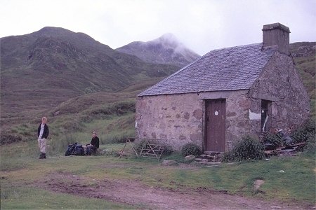
As agreed we consulted beside the cairn. Despite some breaks starting to show the low cloud still seemed firmly in place and looked very unlikely to lift sufficiently in the required time frame to give us any reasonable chance of a decent view. We walked on following the path as it continued northwards for two and a half kilometres to the end of the landrover track from Coriechollie and the bothy. This small building - looking like just half a cottage - nestles between the mounds of morraine at the side of the valley and is not revealled until you are almost at the door. A substantial stream draining the north corrie to Stob Ban provides an ample water supply.
Here we found a couple of leaders, with cycles, awaiting the arrival of a group of walkers (Duke of Edinburgh students) coming up the valley from Ben Alder and Corrour. We settled down for a light lunch as the the sun started to break through and reveal the lesser tops. Even the top of Stob Ban, the lowest of the eastern Grey Corries summits by some 300ft to 600ft, appeared briefly. This conical top (it is not named Stob Ban for nothing) looking surprisingly near as the eye-line looks straight up the north east ridge.
After lunch we set off down the valley - learning from previous visits that the path on the opposite side of the valley proves very difficult to follow lower down we took the valley floor route. Initially the path is impossible to follow as it traverses some boggy ground. However an established path is soon picked up and makes for an easy walk up, down and around the piles of morrain, avoiding as much as possible the sections of boggy ground. The valley provides a delightful mix of cascades, grassy banks - stoney path and bog. As the sun started to break through in earnest it was a pleasant walk in warm sunshine. We passed the group of students as expected in the lower part fo the valley.
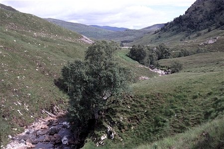
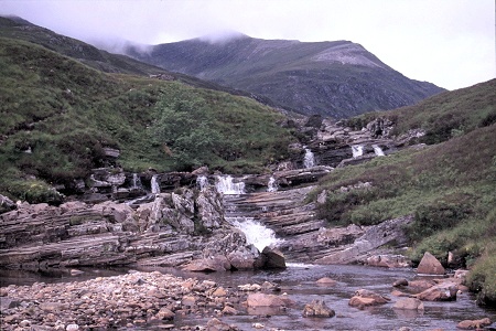
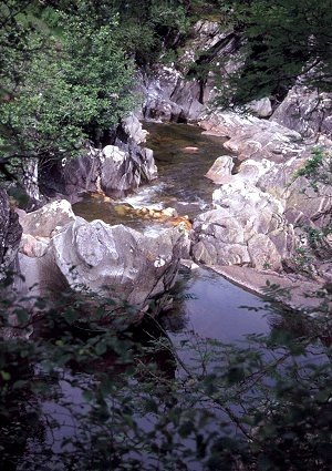
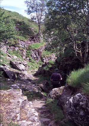
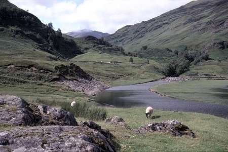
In the lower stretches of the valley, one and a half kilometres from Loch Treig, the valley turns to a more easterly direction to pass under the wooded crags of Creag Ghuanach. After a first set of cascades the valley flattens out, providing a gentle walk on grassy banks, before entering a second set of cascades in a gorge in a final plunge to Loch Treig. This river carries enormous volumes of water when in spate and the rocks are well scoured and sculptured. The path, understandably, keeps a line above the gorges and then, as the river swings left, the path takes a line to the right and descends steeply down dry floored gorge in a separate line to the same target. The route must have been cut by water at some time - presumably before the easier or lower line of the current river course became established. It makes for a surprising, and fitting, end to the valley walk and delivers you at the walls and enclosures to the old lodge at the head of Loch Treig.
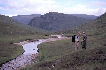
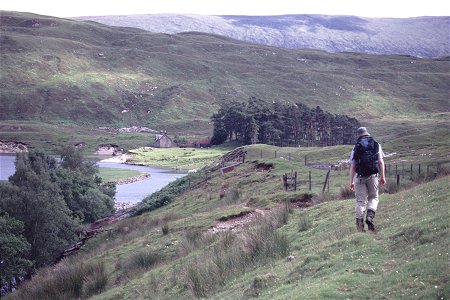
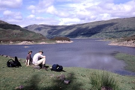
Loch Treig is, of course, dammed and the high water level is considerably higher than it was originally. Much of the flatter grasslands, and associated stone walls, are now below the maximum water level and often submerged. It was certainly true this year, the level of the loch was very high - almost full. A testament to the wet summer. The river, the Abhainn Rath, was backfilled by the high water level and looked very dark and deep. It is bridged at this point ensuring walkers from the north bank can get across if necessary.
Creaguaineach Lodge sits on a knoll of high ground surrounded by closely cropped green grass - manicured by the sheep. The house is in poor repair but is secure and still used from time to time by the estate. Being so near the railway and on a popular walking route there is a fair bit of litter about. A remote spot yes, but not desolate, dilapidated would be more appropriate.
The final leg of the walk is to return upstream to Meanach. The path starts beside the bridge that spans high above the Abhainn Rath. Like the previous river entering Loch Treig the rising of the water level results in the flooding of the narrow gorge that originally carried the river, leaving a deep and dark ribbon of water. Paths run up either side of the river, the northern side (the side we were taking) being the better established and easier going. As before it is a walk through a mixture of cascades, gorges and falls, interspersed with green grassy banks. We soon reached the first bothy at Staoineag, perched on a rocky knoll on the opposite side of the river. The stepping stones were just about visible - a crossing that would soon be difficult or impossible when the river rises.
Beyond the bothy the valley opens out, with significant mounds of morraine lying across the valley floor. Where the valley flattens out the ground gets boggy, but ahead lie more cascades which mark the lip to higher valley - which runs out at a much flatter gradient virtually to the head of Glen Nevis. The path climbs to the right of the cascades and runs into the much more open and remote moorland terrain. The ground turns boggy underfoot again and you constantly weight the options of taking a direct line - across the bog - or follow the river bank which involves frequent jumps to cross the tributaries - especially for those with shorter legs. Surprisingly the final goal of the day remains hidden for a considerable time - even with the trees at Luibelt it is not until the river swings to the left that the buildings come into sight.
We picked as dry a line as we could to reach the front door - from the bothy book a party had called in for lunch, but we were still alone. The weather had continued to clear steadily throughout the afternoon leading to a well settled evening with grand mountain views. We had a quick swim in the river before supper and settling down to sleep. An extremely pleasant day's walk.


Introduction
Day One -Mamore Lodge to
Meanach
Day Three - Stob Ban - The
Grey Corries
Day Four - Meanach to
Corrour
Day Five - Corrour to
Rannoch