.
| Summit: | Sgurr nan Gillean |
| Heights: | 964 m (3167 ft) |
| Map Reference: | NG 472 253 |
| Maps: |
|
| Our Ascents: |
|
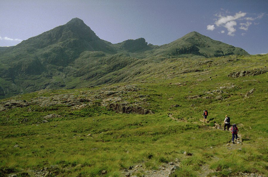
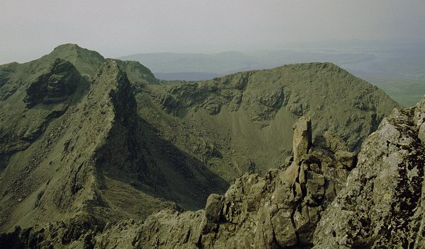
Sgurr nan Gillean is at the north end of the Cuillin ridge and is usually seen across the moor from Sligachan Hotel. The summit forms a perfect pyramid on the skyline to the left of the equally characteristic Basteir Tooth. Not seen from this angle - unless broken mist lingers around the ridges - is the north ridge which runs directly towards you and is known as Pinnacle Ridge for an obvious reason, the Pinnacles. An ascent to the summit is rated as one of the most difficult on the entire ridge - the easiest approach (least difficult) is the south-east ridge (the left-hand skyline) but even this involves some hard scrambling in a very exposed position. This path is known as the Tourist Route and it makes for an exhilarating day out - the route is difficult to follow in mist. The other two ridge approaches are rated as rock climbs - the west ridge (the right-hand skyline) is the easier of the two and rated as a Moderate climb at the foot of the ridge. With the help of a guide during our week's visit in 1999 we were able to ascend by this latter route.
We caught an early ferry across to Kyleakin and drove north to park the car at the roadside beside the Sligachan Hotel. We started walking at 9:40 am with cloud cover still hanging at the 300m level. The past week had been largely hot, sunny and clear and we were hoping that this would continue to give some good views on our first visit to the Cuillin ridge.
We crossed the intervening moorland on what is now the traditional re-constructed path that has been put in on all popular routes. The cloud lifted slightly as we crossed the shoulder into Coire Riabhach. Ahead was a steep climb as we headed south gain the south east ridge and as we reached the skyline we could see over into the corrie on the opposite side. The top was still in mist and as it was now 1:00pm we stopped for a bite of lunch whilst waiting for a band of cloud to pass over.
We moved up the ridge as the terrain narrowed and steepened. As the path becomes more vertical hands are required and it becomes more of a scramble than a walk. The final clamber onto the narrow summit ledge is narrow and exposed on all sides - but there is enough room on the top to settle down for a bite and a cup of soup.
 We sat on the top
for a while watching climbers arriving from along the ridge. We could only see
down below our feet into Lota Corrie and along the ridge for about 1 km.
The summit never cleared and a cold damp mist closed in. Apparently most of the
ridge was clear with some sections standing out above the cloud, but the north
easterly wind kept bringing a never ending stream of cloud over this northerly
section of the ridge.
We sat on the top
for a while watching climbers arriving from along the ridge. We could only see
down below our feet into Lota Corrie and along the ridge for about 1 km.
The summit never cleared and a cold damp mist closed in. Apparently most of the
ridge was clear with some sections standing out above the cloud, but the north
easterly wind kept bringing a never ending stream of cloud over this northerly
section of the ridge.
We started our descent in mist returning along the route of ascent. The cloud level was now higher than during the ascent and we got a much better impression of the enormous size of the mountain. We picked our way down from the ridge to reach the moorland path. With all the recent dry weather there was virtually no water running in the streams high up on the hillside.
We reached Sligachan at 6:00pm and visited the bar for a drink. The sky had cleared by now to reveal most of the ridge although Sgurr nan Gillean stubbornly held onto its cap of cloud. Unfortunately the film in the camera had been loaded incorrectly and we lost all the photos from this days walk.
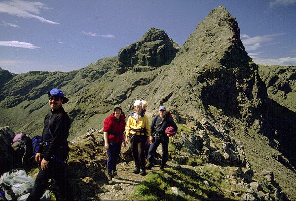
As with our first ascent of this mountain the starting point for the approach across the moor was the Sligachan Hotel. The skies were clear - if a bit hazy - and a stiffer breeze than on previous days gave the promise of a good day out in excellant conditions. At 9:40 am we set off along the Tourist Path, the dry weather of the past few weeks making for easy walking underfoot. At the second bridge we left the usual approach and followed the Allt Dearg Beag towards Coire a' Bhasteir. Above Am Basteir and the Basteir Tooth dominated the skyline behind the corrie.
Hidden beyond the lip to the corrie is the Bhasteir Gorge and the path bears to the east (left) to follow a spur and crossing two knolls to reach the foot of the buttresses under the Pinnacle Ridge. The path stays close to the rock walls climbing steadily and crossing several scree slopes making progress slow and awkward. The advantage of this approach is taken at the final exit onto the ridge as it is more of a traverse into the col rather than the customary steep scramble.
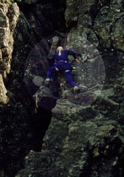
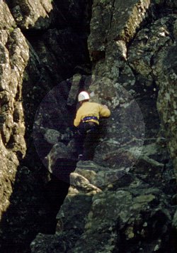
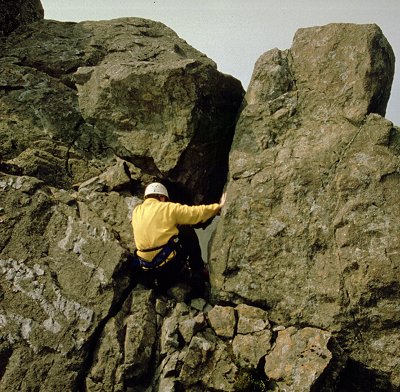
 Once the col is reached we
donned trousers, fleeces and climbing harnesses. We left the rucksacks and
moved a short distance along the ridge to a gully that rises some 60 ft to
theridge above. The climb is rated moderate and fairly straightforward -
a bit awkward getting over a boulder lodged in the gully. We each ascended in
turn fully roped for safety.
Once the col is reached we
donned trousers, fleeces and climbing harnesses. We left the rucksacks and
moved a short distance along the ridge to a gully that rises some 60 ft to
theridge above. The climb is rated moderate and fairly straightforward -
a bit awkward getting over a boulder lodged in the gully. We each ascended in
turn fully roped for safety.
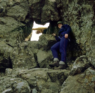
Beyond the gully climb the ascent along the high section of ridge gives hard scrambling with some tremendously exposed steps as you cross gullies following the skyline. Towards the top you pass through a narrow window of rock right on the ridge line before climbing the last few boulders to reach the knife edge of the summit crag.
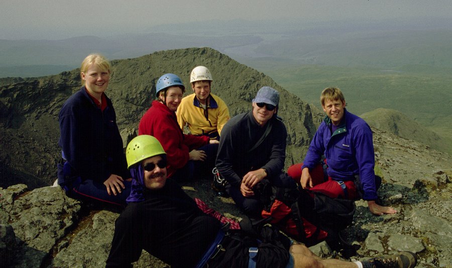
From this elevated viewpoint the entire ridge was in
view - if a bit hazy. The wind had dropped a bit and veered in direction and
gave a hint of rain being brought in. After a rest - and a short lesson of
tunes on the tin whistle - we picked our way back down the ridge. Each of the
party was lowered back down the gully to reach the col. For descent we took the
scree slope directly to the corrie floor and Loch a' Bhasteir. From here
a path sticks to the west (left) of the Bhasteir Gorge keeping to higher
ground well above the crags. This descent gives excellant views back to the
Pinnacle Ridge and the summit crag.
The lip of the corrie has large areas of smoothed rock and the path drops steeply to the moorland below and the start of the long walk back toSligachan. By now the few drops of rain had passed over and the midges emerged in the watery sunshine of the early evening. We passed a family of grouse chicks by the path. These 'Scottish Chickens' as a couple of overseas visitors called them could only be seen when they moved - they just disappeared when they stood still.
We were back in the bar with a couple of pints by 6:30 pm. This was the fourth and penultimate day of our week long visit to Skye and we went on to the Cuillin Hills Hotel in Portree for a celebration supper. We had enjoyed four days of superb weather - would the next day make it five out of five?