| Tops: | Sgurr nan Eag |
| Heights: | Sgurr nan Eag: 924 m Coir' a' Ghrunnda: 697 m |
| Map Reference: | NG 456 196 |
| Maps: |
|
| Our Ascent: |
This was the last day of our week in Skye and having tackled section in the middle and to the north of the ridge we opted to spend this day exploring the southern end. Remarkably this was the fifth day in row when the tops of the high ridge were clear and we had the prospect of another day of near perfect weather. We drove down Glen Brittle to the camp site and parked the car at the car park on the foreshore. The wind had dropped and the midges were out in force - we changed back into trousers and long sleeve shirts and applied the midge creams.
The path starts from the far side of the camp site and climbs across the moorland to a height of 450 ft on a prepared path. The first stream crossed was running with very little water and was full of green algae - this was causing problems in the camp site as it was used as the water supply. By now the breeze had picked up sufficiently to drive off the midges and we changed back to shorts and rinsed off the midge creams. To the north all ridge tops were under a blue sky.
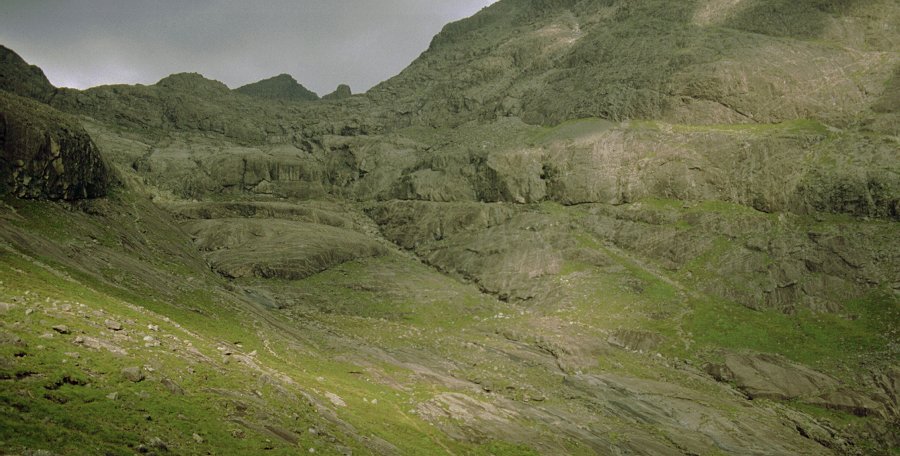
The path eases to a slight gradient as it crosses the open mouth of Coire Lagan - the tops still dark against the skyline. The path has become heavily eroded but as the peat was so dry it was easy going - it would be a very different story in wet weather. The Allt Coire Lagan was running clear - if modestly - and so we took the opportunity of a drink and filled the water bottles before continuing. Beyond the path contours the shoulder of Sron na Ciche to reach the entrance to Coir' a' Ghrunnda. We were on the 'low' path and as we turned into the corrie we were faced with great boiler plates of smoothed rock rising in a series of giant steps to the back of the corrie. Surrounding these is a backdrop of high buttresses to the ridge on the skyline. What strikes you is the sheer size of it all - the area of rock is vast.
There is no way up the centre of the valley and we kept well to the left, under the rock buttresses, scrambling up stony paths, over large boulders and slabs of rock to gain the upper corrie. There are three broad steps to the smoothed boiler plates and over the third you suddenly come across the clear waters of Loch Coir' a' Ghrunnda. This is the highest corrie in the Cuillin and the ridge is only a few hundred feet above. To the left and above the screes rise the steep cliffs to the Sgurr Alasdair complex, to the right steep boulder screes rise at a remarkable angle to the shoulder that leads to Sgurr nan Eag. The backwall ridge that links the two sections is a mass of shattered rock and boulders. Given the broken nature of the rock and the relatively small height difference there are a number of routes from the water's edge to the ridge above.
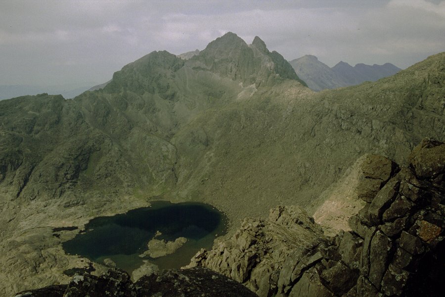
It had taken us a steady three hours walking to reach the lochan and we stopped for lunch and a drink before continuing. Leaving the walking sticks behind, we tackled the steep boulder slopes to the right, clambering in a direct line to the ridge above. The rock was extremely rough and sharp - some had a bubble-like finish and had a very harsh effect on the skin if you caught or fell against it. There were numerous dyke instrutions which were easily picked out by their lighter colour and smoother appearance. It took us 30 minutes to gain the shoulder above - the climb gives some truely magnificent views back across the corrie to Sgurr Alasdair.
 Once on the
ridge, the actual Munro summit is some way back. After crossing one
particularly narrow section, the ridge widens and the path picks its way
between boulders and outcrops - still pretty hard going even though there is
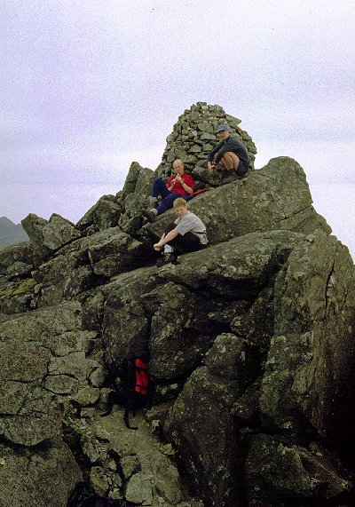
virtually no height gain. The summit is marked by a well made cairn perched on
top of a narrow outcrop and we settled down for a rest and bite to take in the
view - and for a second lesson on the tin whistle. Below is Loch Coruisk, to
the north the rocky ridges of Sgurr Dubh Mor, behind this are Sgurr
Dearg and the In Pin; and the northern peak of Sgurr nan
Gillean is hidden from view.
Once on the
ridge, the actual Munro summit is some way back. After crossing one
particularly narrow section, the ridge widens and the path picks its way
between boulders and outcrops - still pretty hard going even though there is
virtually no height gain. The summit is marked by a well made cairn perched on
top of a narrow outcrop and we settled down for a rest and bite to take in the
view - and for a second lesson on the tin whistle. Below is Loch Coruisk, to
the north the rocky ridges of Sgurr Dubh Mor, behind this are Sgurr
Dearg and the In Pin; and the northern peak of Sgurr nan
Gillean is hidden from view.
The return was by the route of ascent - a laborious clamber down the boulders whilst being very aware of the steepness of the slope. Returning to the lochan below we collected the sticks, then we picked our way coire. By now the skies had cleared and the sun was out to highlight the extensive rock structures. We kept to the high path on our exit of the corrie - this skirts above a buttress to turn the shoulder without descending the final section of slabs in the centre. Once out of the corrie it was a long three and a half km walk back to Glen Brittle. By now the sun was shining on the coastline and by the time we got back to the cars (6:15 pm) the ridge was clear and almost entirely bathed in sunshine. We were all knackered.
This day had been the fifth and last day on Skye and we had had four full days on the high ridges - five Munro summits in four days. It had been a magnificent week and we drove slowly back up the valley for a drink at the Sligachan Hotel. We had suppe here before returning to Portree for a shower and bed.