Beinn Alligin
| Tops: |
- Sgurr Mhor
- Tom na Gruagaich
|
| Heights: |
- Sgurr Mhor: 986m
- Tom na Gruagaich: 904m
|
| Map Ref: |
- Sgurr Mhor: NG 866613
- Tom na Gruagaich: NG 859602
|
| Maps: |
- OS Sheets (1:50000): 24
- OS Sheet (1:25000): Sheet 8
- Harveys Superwalker: Torridon
|
| Our Ascents: |
|
| The View: |
|
Introduction
The most westerly of the Munros in Torridon, Beinn Alligin is not such
an extensive or imposing mountain as it's near neighbours but this is to it's
advantage. A full traverse of the mountain is well within the bounds of a day's
walk and offers some excellant ridge walking. The mountain is best viewed from
the south over Upper Loch Torridon when the full extent of the tops and ridges
can be seen. The nearest top to the roadside is Tom na Gruagaich (the 'Tom')
which is the most rounded but, despite sporting the trig point, is not the
highest. This honour falls to Sgurr Mhor which is readily identified by large
cleft - Eag Dhubh - that runs diagonally across the face of the cliffs right to
the summit. To the east is a lower ridge showing three distinct tops - the
famous Horns of Alligin - which offer some splendid narrow ridge scrambling.
You can tackle the circuit in either direction and guides are split
about which is best. If you don't fancy the traverse of the Horns then you have
little choice, but if you do then I would recommend anti-clockwise with the
Horns first. There is no real difficulty on the traverse provided you don't
mind heights and a bit of handwork; one guide grades the ridge as similar to
Striding Edge on Helvellyn in Cumbria (which is about right) but somewhat
longer and higher (also about right). It is well worth the outing.
Our Ascent
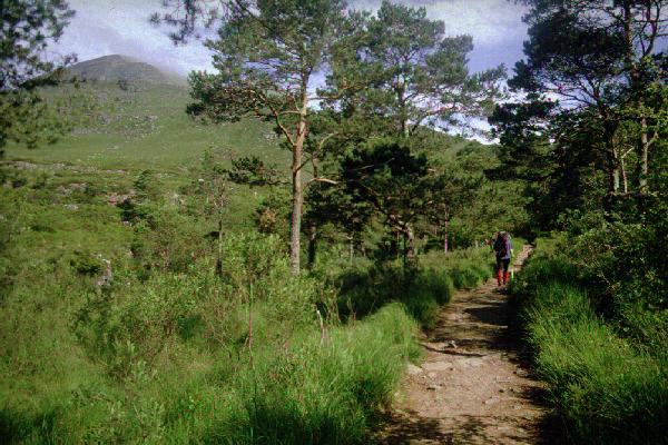
The weather forecast was the best of week so we were up promptly and
drove down to Torridon and parked in the car park at the foot of the Coire Mhic
Nobuil path. The nearest top, the 'Tom' had cleared of mist but the other tops
drifted in and out of cloud all morning. We had intended making the circuit in
a clockwise direction (tackling the 'Tom' first) and followed the path on the
east side of the river on the understanding that there was a crossing after
half a mile or so. However we missed this turn and so decided to follow
everyone else and reverse the route and tackle the Horns first. The path is
well used and crosses first the main watercourse of Abhainn Coire Mhic
Nobuil and then the tributary of Allt a'Bhealaich, both of these
being bridged. It took us one hour to cover the two and half miles, and 1000ft
ascent, to the foot of the ridge under the Horns. It was now 11:00am and we
stopped for a quick bite and a chat with other groups taking advantage of the
good weather.
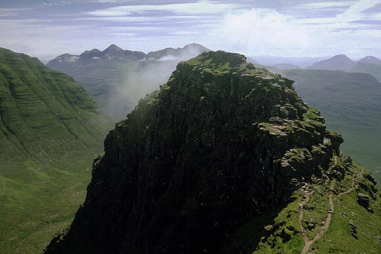
The first 150m of climb was virtually straight up with a stiff scramble
over the sandstone boulders and crags. There was nothing too difficult although
it was much easier in ascent than descent. Susan was hampered by shorter legs -
or 'ducks disease' as she commented to other walkers. The gradient eases
slightly before a final assault to the first pinnacle - from below there
appears to be four horns but in reality the third and fourth merge with no drop
between them. It was now 12:00 and we stopped to change film and take in the
view of the surrounding mountains. Liathach had a halo of cloud with the jagged
ridge standing out; further afield the Cuillin ridge of Skye was also visible
above the cloud.
The sandstone ridge now narrows and there are two sharp drops - and
successive climbs - to traverse the two remaining Horns. The last Horn has a
short narrow stretch of ridge and we stopped here for lunch still with the
cloud drifting in and out around us. There follows a steep drop to the final
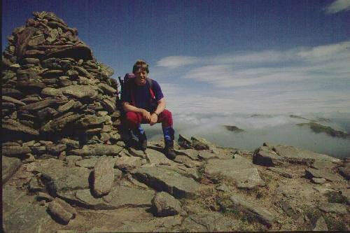
col then a long steady climb to the Munro top of Sgurr Mhor.
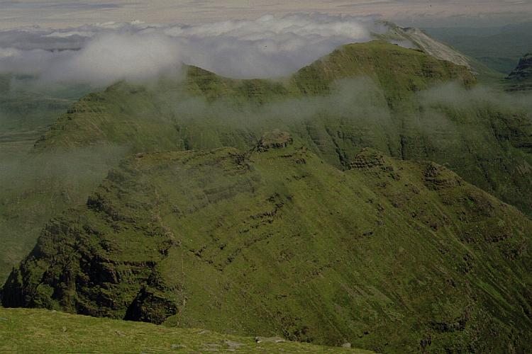 We rested on the
top taking in the panoramic view - there was cloud over the coast and on some
tops but this was ever changing as the mist rolled between the glens. There
were fine views of Beinn Dearg - the near neighbour to the east - although
Beinn Eighe beyond was more heavily clad in cloud with the tops free. Liathach
in the south east had by now largely thrown off the cloud from its ridges.
We rested on the
top taking in the panoramic view - there was cloud over the coast and on some
tops but this was ever changing as the mist rolled between the glens. There
were fine views of Beinn Dearg - the near neighbour to the east - although
Beinn Eighe beyond was more heavily clad in cloud with the tops free. Liathach
in the south east had by now largely thrown off the cloud from its ridges.
The ridge swings west, skirting the top of the great gulley Eag
Dhubh that splits the south facing cliffs, before turning south to the
second main top of Tom na Gruagich. The intervening drop is 200m and whilst
much easier than the earlier climb it was still too steep and rough to be
called a 'stroll'. There were more people about brought out by the good weather
and the more popular ascent from the west - many of them not liking the look of
the Horns and opting to return by the route of ascent. It seemed a long climb
to reach the trig point which was found perched on a narrow crag above the
north east facing cliffs. Gentler slopes run to the west and south-west. We had
a final look round taking in a full
panorama from the north over all the Torridon tops to the south west; the
Horns were now free of mist.
It was 4:00pm, we had lounged on the tops for some time, as we started a
descent doewn the gully of Coire nan Laogh - not too steep but a dirty path. We
followed the obvious path path over the shoulder in a direct line to the
starting point. This actually leaves you 500ft too high and a nasty steep
descent down a heavily eroded and washed out path to reach the road.
It was 5:45pm as we walked into the car park where we changed out of the
boots and drove round the loch to view the mountain from the south. Returning
past the Loch Torridon Hotel with its new Public Bar building we stopped for a
shower at the facilities in Torridon before driving round to the Loch Maree
Hotel for supper; we were camped at Taagan and fancied a change of venue for
the evening.
References
- The Classic Walks includes a full traverse of the mountain -
with some impressive pictures - taking the circuit in a clockwise
direction.
- Ralph Storer also includes the mountain - this time ant-clockwise -
in the 100 Best Routes on Scottish Mountains.
- Muriel Gray's video The Munro Show II includes a traverse of
Ben Alligin.


