Flowerdale Forest
| Hills: |
- Meall a' Ghlas Leothaid
- Meall na Meine
- Meall Lochan Chleirich
|
| Loch: |
|
| Map Reference: |
|
| Maps: |
- OS Sheets (1:50000): 19
- Harveys Superwalker (1:25000): Torridon
|
| Our Walks: |
|
Introduction
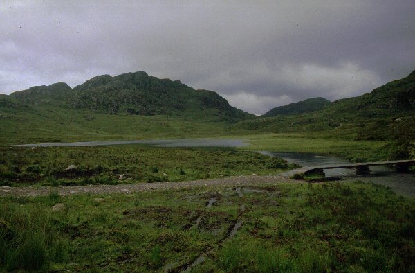 As you drive
towards Gairloch the road leaves the shores of Loch Maree at Slattadale and
strikes west to the head of the gorge that carries the River Kerry into Loch
Gairloch. The road passes Loch Bad an Sgalaig which has been dammed to
provide the water supply for the power station lower down the glen. This loch
is quite large - it covers about one square kilometre - and the raised water
level has linked it to two other lochs, Dubh Loch to the south, and the
deminutive Am Feur-Loch a few hundred metres back up the road. Here
there is a roadside tin shed and opposite a wooden bridge gives access to an
obvious and well constructed path that snakes off into the hills.
As you drive
towards Gairloch the road leaves the shores of Loch Maree at Slattadale and
strikes west to the head of the gorge that carries the River Kerry into Loch
Gairloch. The road passes Loch Bad an Sgalaig which has been dammed to
provide the water supply for the power station lower down the glen. This loch
is quite large - it covers about one square kilometre - and the raised water
level has linked it to two other lochs, Dubh Loch to the south, and the
deminutive Am Feur-Loch a few hundred metres back up the road. Here
there is a roadside tin shed and opposite a wooden bridge gives access to an
obvious and well constructed path that snakes off into the hills.
A guide recommends a round on the three smaller tops - Meall a' Ghlas
Leothaid, Meall na Meine and Meall Lochan Chleirich - that
can be seen from the road, or an ascent of Beinn an Eoin to the south,
or just a walk to Loch na h-Oidhche. Plenty of options to follow here
then.
Our Walk
 The weather was poor with a
misty rain coming off the sea. An ideal day for a lower level walk and surely
something would clear during the day. We had arrived early - around 9:30am - so
we packed in a leisurely manner and started along the track as it climbs
steadily between the two nearest hills. Even these hills were in cloud - only
600ft up - so we continued along the path. The area is now fenced against deer
and was being planted - thousands of upturned sods of peat each with a sapling
added - or about to be added. The new 1:25000 map marks the fence showing that
it circles all three hils in the immediate area.
The weather was poor with a
misty rain coming off the sea. An ideal day for a lower level walk and surely
something would clear during the day. We had arrived early - around 9:30am - so
we packed in a leisurely manner and started along the track as it climbs
steadily between the two nearest hills. Even these hills were in cloud - only
600ft up - so we continued along the path. The area is now fenced against deer
and was being planted - thousands of upturned sods of peat each with a sapling
added - or about to be added. The new 1:25000 map marks the fence showing that
it circles all three hils in the immediate area.
The path climbs to the shallow col between Meall a' Ghlas
Leothaid and Meall na Meine, by which time we in the low cloud and
it had started to rain. A new track has been cut south west from here (not
marked on the 1:50000 map) presumably to give acces to the planting area to the
west and a couple of wooden huts set back from the path on the left. The
Abhainn a Gharbh Choire is now joined at a point where it turns sharply
south west to cut a course to the loch. This is a significant river and it
forms an impressive cascade as it enters the loch two kilometres downstream -
this can just be seen from the road.
As you follow the river upstream you find it has cut a steep and
straight gorge which is probably delightful - even spectacular - but we could
not see it. The path keeps above the steep sides and only rejoins the river
where the banks open out. Here we meet the far side of the deer fence where a
gate gives access to open hillside. The river is bridged here - although the
structure does not give much confidence. The path climbs slightly away from the
river passing over the shoulders of several knolls that loomed up out of the
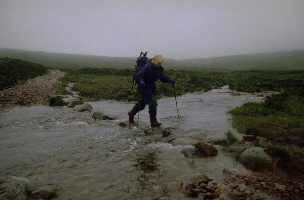
mist. The only tricky bit on the walk was fording the Abhainn Loch na
h-Oidhche by the stepping stones as all the recent rain had raised the
water level considerably. The river is one of two that drain Loch na h-Oidhche
- the single outfall divides after about 1 km with one side flowing NW beside
the path to Loch Bad an Sgalaig and the other running NE across the path
to Loch Garbhaig and Loch Maree (over the Victoria Falls). This
is a most unusual feature and we did not appreciate this until we reached the
crossing - we had only glanced at the map and thought the river drained in the
opposite direction to feed the river we had walked beside. To find it flowing
in the wrong direction (and we were still in mist) caused us to study the
contours more closely!
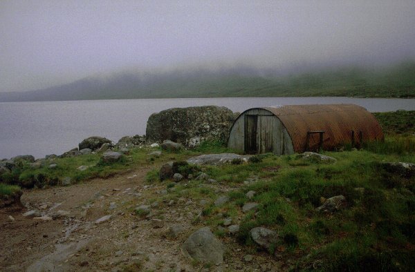 From the stream crossing it it
is a short 2km uphill to the corrugated iron sheet hut at the north end of
Loch na h-Oidhche. The track is wide and well maintained throughout with
ducts to take water under the surface rather than wash it out. The surface is
not so good as it reaches the loch, and probably gets rougher as it takes to
the eastern shore and continues to the far end. A party pulled out in a boat to
do some fishing as we arrived (12:15pm) so we let ourselves into the hut for
shelter from the misty rain. The cloud eased slightly so we could see the
length of the loch - even glimpsed the outline of the ridge on Baosbheinn - but
that was it.
From the stream crossing it it
is a short 2km uphill to the corrugated iron sheet hut at the north end of
Loch na h-Oidhche. The track is wide and well maintained throughout with
ducts to take water under the surface rather than wash it out. The surface is
not so good as it reaches the loch, and probably gets rougher as it takes to
the eastern shore and continues to the far end. A party pulled out in a boat to
do some fishing as we arrived (12:15pm) so we let ourselves into the hut for
shelter from the misty rain. The cloud eased slightly so we could see the
length of the loch - even glimpsed the outline of the ridge on Baosbheinn - but
that was it.
After lunching we set off back along the path still clad in full
waterproofs. The cloud had lifted a couple of hundred feet so we had a slightly
wider field of view, but the rain returned and we trudged back into the wind
getting pretty well soaked through. We passed a couple of other families who
also had hoped for kinder weather.
We were back at the car by 2:15pm as the rain stopped and cloud started
to lift. We bought some postcards and retired to a bar in Gairloch bemoaning
the weather. The walk itself could be extremely pleasant - with or without
climbing the hills - similar to the walk above Loch Gruinard to the north, or
even the approach walk to Suilven in Assynt. A return in clearer weather would
be appropriate.


